IMAGES TAKEN NEAR TO
Tyntesfield, Wraxall, BRISTOL, BS48 1PA
Introduction
This page details the photographs taken nearby to BS48 1PA by members of the Geograph project.
The Geograph project started in 2005 with the aim of publishing, organising and preserving representative images for every square kilometre of Great Britain, Ireland and the Isle of Man.

There are currently over 7.5m images from over14,400 individuals and you can help contribute to the project by visiting https://www.geograph.org.uk
Image Map (Loading...)


Getting Data...Please wait
Leaflet Map data © OpenStreetMap
Images are licensed for reuse under creativecommons.org/licenses/by-sa/2.0
Notes
- Clicking on the map will re-center to the selected point.
- The higher the marker number, the further away the image location is from the centre of the postcode.
Image Listing (16 Images Found)
Images are licensed for reuse under creativecommons.org/licenses/by-sa/2.0
Image
Details
Distance
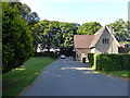
2
Tyntesfield, Clevedon Lodge
Lodge for the Tyntesfield estate, built in the mid-nineteenth century. Now the main vehicular access to the estate. Grade II listed building (List Entry Number: 1061340 https://historicengland.org.uk/listing/the-list/list-entry/1061340 Historic England).
Image: © David Dixon
Taken: 20 Jul 2021
0.00 miles
3
Bus stops on B3128 outside Tyntesfield
Bus stops on each side of the road at the entrance to Tyntesfield House and park
Image: © David Smith
Taken: 26 Jul 2016
0.03 miles
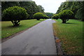
4
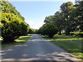
Main Entrance to Tyntesfield
This entrance is on Clevedon Road
Image: © PAUL FARMER
Taken: 20 Jul 2016
0.03 miles
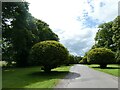
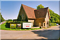
6
Entrance to Tyntesfield
The main visitor entrance to the Tyntesfield House.
Image: © Philip Halling
Taken: 10 Sep 2011
0.08 miles
7
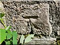
Ordnance Survey Cut Mark
This repositioned OS cut mark can be found on the NE side of the road. It marked a point 139.894m above mean sea level.
Image: © Adrian Dust
Taken: 5 Aug 2022
0.09 miles
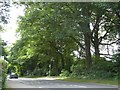
8
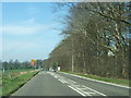
Approaching the turning to Portbury
Looking west along the B3128 past a works site on the right, towards the junction with Portbury Lane, which leads north to near junction 19 of the M5.
Image: © Ruth Riddle
Taken: 23 Mar 2012
0.14 miles
9
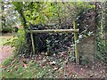
Disused Path at Tyntesfield
A former walled path off the North Drive at Tyntesfield, now superseded by a public footpath on the north side. The end of the south (right) wall carries a cut bench mark. See https://www.geograph.org.uk/photo/7004050 for a close-up and https://www.bench-marks.org.uk/bm132254 for details.
Image: © Brian Westlake
Taken: 12 Oct 2021
0.15 miles
10
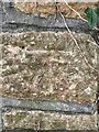
Cut bench mark on a wall end at Tyntesfield
A cut bench mark on the end of a wall at Tyntesfield. See https://www.geograph.org.uk/photo/7004045 for a wider view and https://www.bench-marks.org.uk/bm132254 for details of the mark.
Image: © Brian Westlake
Taken: 12 Oct 2021
0.15 miles