IMAGES TAKEN NEAR TO
Ironmould Lane, BRISTOL, BS4 4TZ
Introduction
This page details the photographs taken nearby to Ironmould Lane, BS4 4TZ by members of the Geograph project.
The Geograph project started in 2005 with the aim of publishing, organising and preserving representative images for every square kilometre of Great Britain, Ireland and the Isle of Man.

There are currently over 7.5m images from over14,400 individuals and you can help contribute to the project by visiting https://www.geograph.org.uk
Image Map
Images are licensed for reuse under creativecommons.org/licenses/by-sa/2.0
Notes
- Clicking on the map will re-center to the selected point.
- The higher the marker number, the further away the image location is from the centre of the postcode.
Image Listing (31 Images Found)
Images are licensed for reuse under creativecommons.org/licenses/by-sa/2.0
Image
Details
Distance
1
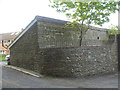
An outbuilding on Ironmould Lane
Part of Heath Farm this building bears a benchmark - see Image
Image: © Neil Owen
Taken: 25 Apr 2020
0.02 miles
2
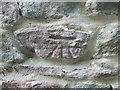
Benchmark on Ironmould Lane
This cutmark is relatively new, being made after WWII. However, the fresh-looking mortar gives the impression the wall has been rebuilt afterwards. See Image] for a wider view and https://www.bench-marks.org.uk/bm119448 for the entry in the Benchmark Database.
Image: © Neil Owen
Taken: 25 Apr 2020
0.03 miles
3
Ironmould Lane, Bristol BS4
Ironmould Lane heads east away from Broomhill Road.
Image: © Jaggery
Taken: 5 Nov 2012
0.04 miles
4
Raymill, Brislington, Bristol
Behind the camera, a street name sign pointing along the path shows RAYMILL BS4.
Image: © Jaggery
Taken: 5 Nov 2012
0.08 miles
5
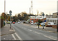
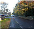
2010 : Looking South on Broomhill Road, Brislington
Business premises to the right, private housing out of sight to the left.
The large white van in the distance is emerging from Ironmould Lane.
Late November but a hint of autumn remains in the trees.
Image: © Maurice Pullin
Taken: 26 Nov 2010
0.08 miles
6
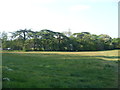
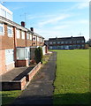
Trees near Heath Farm
Most of the area around Brislington featured the largely rural landscapes of the past before the trading estates took over. In a few spots the appearance of that past still catch the eye.
Image: © Neil Owen
Taken: 25 Apr 2020
0.08 miles
7
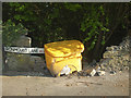
True grit
A grit bin on Ironmould Lane looks like it may have knocked down the wall.
Image: © Neil Owen
Taken: 25 Apr 2020
0.09 miles
8
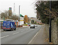
2010 : Broomhill Road, Brislington, Bristol
Looking north toward Broomhill and St.Anne's Park.
The boundary wall of St.Brendan's R.C. College is on the right.
Business premises to the left include Alligator Self Storage Co. Ltd. who also sell boxes (note the green alligator at the top of the chimney). The blue van belongs to a gas installation firm, possibly British Gas.
The housing at the bottom of the hill looks like the 1960's or 70's style.
The turning to the right at the end of the stone wall is Ironmould Lane.
Image: © Maurice Pullin
Taken: 26 Nov 2010
0.09 miles
9
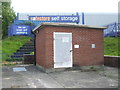
A pumping station on Broomhill Road
The station stands in front of a typical modern industrial estate building. Before the land was open farmland with a pond nearby.
Image: © Neil Owen
Taken: 17 May 2020
0.09 miles
10
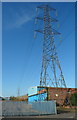
Electricity pylon, Brislington, Bristol
Viewed across Broomhill Road near Brislington Trading Estate.
Image: © Jaggery
Taken: 5 Nov 2012
0.11 miles