IMAGES TAKEN NEAR TO
Upton Lane, BRISTOL, BS41 8NR
Introduction
This page details the photographs taken nearby to Upton Lane, BS41 8NR by members of the Geograph project.
The Geograph project started in 2005 with the aim of publishing, organising and preserving representative images for every square kilometre of Great Britain, Ireland and the Isle of Man.

There are currently over 7.5m images from over14,400 individuals and you can help contribute to the project by visiting https://www.geograph.org.uk
Image Map
Images are licensed for reuse under creativecommons.org/licenses/by-sa/2.0
Notes
- Clicking on the map will re-center to the selected point.
- The higher the marker number, the further away the image location is from the centre of the postcode.
Image Listing (11 Images Found)
Images are licensed for reuse under creativecommons.org/licenses/by-sa/2.0
Image
Details
Distance
1
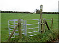
Shocking stile
Here's a nice little kissing gate to allow passage through the fields of what must surely hold livestock. The animals are suitably restrained by an electric fence. But just to make sure the current isn't stopped, there is a length of flex to connect the two ends of the wire. Just keep your head low when using it....
Also: Image
Image: © Neil Owen
Taken: 31 Oct 2010
0.14 miles
2
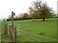
Electric kissing gate
To allow the current to pass along the entire distance of the fence, a length of flex connects across the kissing gate.
Also: Image
Image: © Neil Owen
Taken: 31 Oct 2010
0.14 miles
3
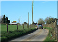
2012 : Upton Lane looking toward Upton Farm and Dundry
Two hundred and seventy degrees of marvellous views and he has to take a picture of a road.
Image: © Maurice Pullin
Taken: 25 Mar 2012
0.17 miles
4
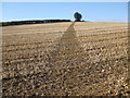
Now that the crop has been cleared
The footpath is clear to see.
Image: © Neil Owen
Taken: 18 Nov 2019
0.18 miles
5
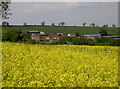
The colour of May
Oilseed rape marks the month out with a strident yellow. Across the fields is East Dundry and the buildings of Walnut Farm.
Image: © Neil Owen
Taken: 18 May 2018
0.18 miles
6
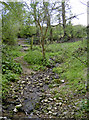
A wet walk
At least in times of heavy rainfall. The valley south of East Dundry is home to a number of springs, but today this one is a gentle trickle. The footpath pretty much follows it downhill.
Image: © Neil Owen
Taken: 5 May 2016
0.21 miles
7
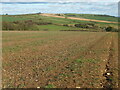
The lines constrain to the past
This open field is awaiting the arrival of Spring. However, the official maps insist that the district boundaries wander quite markedly across it. In times past (post-war) there would have been several hedgelines, now grubbed out.
Image: © Neil Owen
Taken: 16 Mar 2021
0.22 miles
8
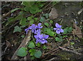
Violets by the spring
The deep, damp and shady valley near East Dundry is partly formed by a couple of springs that flow down the steep sides. Among the stones and hedges are these shy but attractive violets.
Image: © Neil Owen
Taken: 5 May 2016
0.23 miles
9
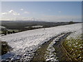
A dusting over Dundry
Yesterday had been a particularly wet day; incessant rain all afternoon carried on into evening, whereupon it turned to snow overnight. The temperatures narrowly avoided dropping to zero and the air was slowly warming up, leading to some flooding in places. By this time, the lower reaches around the Mendips were clear of snow, whilst the higher ground clung on to the white stuff.
Image: © Neil Owen
Taken: 27 Dec 2017
0.23 miles
10
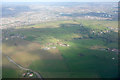
Buildings along Upton Lane from the air
In the centre are Upton and Watercress Farms. On the left is the hamlet of Maiden Head. Slightly up and on the right is the village of East Dundry. Beyond is a view across southern Bristol.
Image: © Derek Harper
Taken: 20 Feb 2018
0.24 miles