IMAGES TAKEN NEAR TO
Dundry Lane, BRISTOL, BS41 8JF
Introduction
This page details the photographs taken nearby to Dundry Lane, BS41 8JF by members of the Geograph project.
The Geograph project started in 2005 with the aim of publishing, organising and preserving representative images for every square kilometre of Great Britain, Ireland and the Isle of Man.

There are currently over 7.5m images from over14,400 individuals and you can help contribute to the project by visiting https://www.geograph.org.uk
Image Map
Images are licensed for reuse under creativecommons.org/licenses/by-sa/2.0
Notes
- Clicking on the map will re-center to the selected point.
- The higher the marker number, the further away the image location is from the centre of the postcode.
Image Listing (95 Images Found)
Images are licensed for reuse under creativecommons.org/licenses/by-sa/2.0
Image
Details
Distance
1
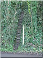
A steep path by Grove Farm
The footpath across the common takes a sudden and severe drop as it approaches Dundry Lane. The steps are narrow, mossy and (importantly) there is no handrail to assist walkers. It's quite a test to not land in the middle of the road.
Image: © Neil Owen
Taken: 10 Nov 2020
0.02 miles
2
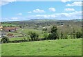
Dundry Hill
From Kingcott Farm. The local river, Land Yeo, rises on the Hill and flows south of the farm, through neighbouring fields, where it used to power a water mill - now converted to holiday homes.
Image: © Anthony O'Neil
Taken: 5 Apr 2021
0.09 miles
3
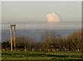
A strange cloud
Bristol and the environs were almost fully covered by a thick blanket of cloud all day. A large anti-cyclone was reluctant to move much, so trapping a lot of cold air and fog. From the high point on Dundry, the fog lay below and made islands of some parts. Note the yellowish band of atmosphere above the grey cloud, where some pollution hangs heavy.
Further to the north, something is clearly causing a stir. The massive white cloud bursting above the layers might almost be mistaken for a more atomic version.
Image: © Neil Owen
Taken: 1 Dec 2016
0.10 miles
4
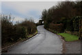
Dundry Lane
Lane ascending towards the village of Dundry - a thoroughfare that carries more than its fair share of traffic, compared to its size.
Image: © Chris Heaton
Taken: 9 Feb 2016
0.12 miles
5

Entering Dundry
Following Dundry Lane into the village
Image: © Chris Heaton
Taken: 9 Feb 2016
0.12 miles
6
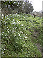
Cascade of Galanthus
Some snowdrops, tumbling down the steep junction along Dundry Lane.
Image: © Neil Owen
Taken: 4 Mar 2014
0.14 miles
7
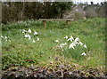
Snowdrop seating
A handy bench to take in the view over Bristol from Dundry, including the immediate sight of snowdrops.
Image: © Neil Owen
Taken: 4 Mar 2014
0.15 miles
8
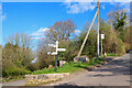
Dundry Lane
Bus stop at the road junction.
Image: © Wayland Smith
Taken: 5 Apr 2021
0.15 miles
9
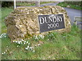
Dundry's stone
A rather nice piece of what looks like granite to greet the visitor to the lofty village of Dundry. The snowdrops are a seasonal touch.
Image: © Neil Owen
Taken: 4 Mar 2014
0.15 miles
10
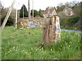
Stump seat
An old tree, now a public noticeboard-cum-seat.
Image: © Neil Owen
Taken: 4 Mar 2014
0.15 miles