IMAGES TAKEN NEAR TO
Broadcroft, BRISTOL, BS40 8QG
Introduction
This page details the photographs taken nearby to Broadcroft, BS40 8QG by members of the Geograph project.
The Geograph project started in 2005 with the aim of publishing, organising and preserving representative images for every square kilometre of Great Britain, Ireland and the Isle of Man.

There are currently over 7.5m images from over14,400 individuals and you can help contribute to the project by visiting https://www.geograph.org.uk
Image Map
Images are licensed for reuse under creativecommons.org/licenses/by-sa/2.0
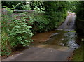
Notes
- Clicking on the map will re-center to the selected point.
- The higher the marker number, the further away the image location is from the centre of the postcode.
Image Listing (41 Images Found)
Images are licensed for reuse under creativecommons.org/licenses/by-sa/2.0
Image
Details
Distance
1
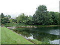
Chew Magna Reservoir
A nineteenth century creation, the damming of the Winford Brook enabled Bristol Water Company to ensure supplies to the village and beyond. Today, Knowle Angling Club enjoy trout fishing here.
Image: © Neil Owen
Taken: 29 Jun 2017
0.07 miles
2
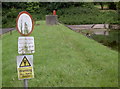
Warning: non-native species!
The reservoir is stocked with trout and perhaps other things too.
Image: © Neil Owen
Taken: 29 Jun 2017
0.08 miles
3
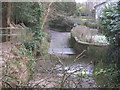
Ford and footbridge across the Winford Brook
Image: © Dr Duncan Pepper
Taken: 19 Feb 2014
0.09 miles
4
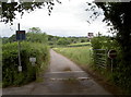
To Fairwater Farm
The road runs along the side of the Chew Magna reservoir. It is also a public footpath.
Image: © Neil Owen
Taken: 29 Jun 2017
0.09 miles
5
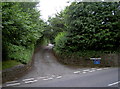
The north end of Chillyhill Lane
Interestingly, the lane is a byway, but for a fair length of it too narrow for most cars to use. The 'No Through Road' sign gives authority.
Image: © Neil Owen
Taken: 29 Jun 2017
0.09 miles
6
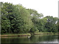
Serenity on a calm day
A swan gently and gracefully slips past the trees of Chew Magna reservoir.
Image: © Neil Owen
Taken: 29 Jun 2017
0.09 miles
7
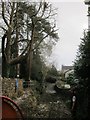
Forestry, Ford and Footbridge
Hard to believe that this is a public road-just at the point where the Winford Brook flows out of the Chew Magna reservoir. Look carefully and you will see a tree surgeon perched in the top of the tree.
Image: © Dr Duncan Pepper
Taken: 19 Feb 2014
0.09 miles
8
Back up the Brook
The ford at Chew Magna's Dark Lane allows the water flowing from the west end of Dundry Hill to go through the village. The water is known as the Winford Brook or Littleton Brook - both rise near the respective villages and converge a short distance upstream.
Image: © Neil Owen
Taken: 29 Jun 2017
0.09 miles
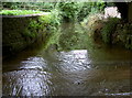
9
The ford on Dark Lane
Looking southwards across the gentle stream.
Image: © Neil Owen
Taken: 29 Jun 2017
0.10 miles
10
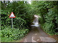
Ford at Dark Lane
The footbridge up the lane has been taken down, so traffic can take a bit of a run-up at the water hazard.
Image: © Neil Owen
Taken: 29 Jun 2017
0.10 miles