IMAGES TAKEN NEAR TO
Regil Lane, BRISTOL, BS40 8AX
Introduction
This page details the photographs taken nearby to Regil Lane, BS40 8AX by members of the Geograph project.
The Geograph project started in 2005 with the aim of publishing, organising and preserving representative images for every square kilometre of Great Britain, Ireland and the Isle of Man.

There are currently over 7.5m images from over14,400 individuals and you can help contribute to the project by visiting https://www.geograph.org.uk
Image Map
Images are licensed for reuse under creativecommons.org/licenses/by-sa/2.0
Notes
- Clicking on the map will re-center to the selected point.
- The higher the marker number, the further away the image location is from the centre of the postcode.
Image Listing (72 Images Found)
Images are licensed for reuse under creativecommons.org/licenses/by-sa/2.0
Image
Details
Distance
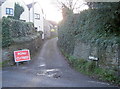
1
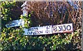
Old Direction Sign - Signpost by the B3130, Chew Road, Winford
Replacement pyramid finial - 2 arms; Somerset SCC pyramid by the B3130, in parish of Winford (North Somerset District), junction with Regil Lane.
Surveyed
Milestone Society National ID: SO_ST5464
Image: © Milestone Society
Taken: Unknown
0.07 miles
2
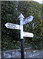
Modern repairs, modern typeface
This signpost, typical of the type found in rural Somerset, has had a few losses over time. A couple of signs have been broken and subsequent replacements which have a different typeface and material. Incidentally, the original signs have the information on both sides.
Image: © Neil Owen
Taken: 12 Nov 2017
0.07 miles
3
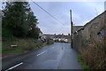
Regil Lane entering Winford
Frog Lane joining from the left
Image: © Tim Heaton
Taken: 8 Feb 2016
0.10 miles
5
Frog Lane is closed
A small lane, partially blocked by a bit of digging.
Image: © Neil Owen
Taken: 12 Nov 2017
0.10 miles
6
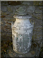
Croak Cottage
A frog on a milk churn, in Frog Lane naturally.
Image: © Neil Owen
Taken: 12 Nov 2017
0.11 miles
7
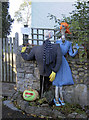
Lucy's Secret Weapon?
Another entrant in the village scarecrow competition. Note the unusual pumpkin design.
Image: © Neil Owen
Taken: 12 Nov 2017
0.11 miles
8
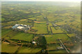
Landscape near Winford from the air
See Image for another view of the Avon Livestock Centre. At lower right is a stretch (white) of the Winford Aqueduct, and part of Winford village is on the right.
Image: © Derek Harper
Taken: 7 Mar 2023
0.11 miles
9
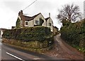
Looking towards Court Farm from the B3130
Image: © David Gearing
Taken: 18 Jun 2013
0.11 miles
10
Almost covered up
The Monarch's Way path crosses the B3130 and goes across farmland to Winford here. The sign is almost covered up by some legal notices. Adding to the welcome was the fact that the large gate that marks this farm track was swung open and chained to the kissing gate that should have been used!
Image: © Neil Owen
Taken: 8 Nov 2017
0.12 miles