IMAGES TAKEN NEAR TO
Iwood, Wrington, BRISTOL, BS40 5NX
Introduction
This page details the photographs taken nearby to BS40 5NX by members of the Geograph project.
The Geograph project started in 2005 with the aim of publishing, organising and preserving representative images for every square kilometre of Great Britain, Ireland and the Isle of Man.

There are currently over 7.5m images from over14,400 individuals and you can help contribute to the project by visiting https://www.geograph.org.uk
Image Map (Loading...)


Getting Data...Please wait
Leaflet Map data © OpenStreetMap
Images are licensed for reuse under creativecommons.org/licenses/by-sa/2.0
Notes
- Clicking on the map will re-center to the selected point.
- The higher the marker number, the further away the image location is from the centre of the postcode.
Image Listing (4 Images Found)
Images are licensed for reuse under creativecommons.org/licenses/by-sa/2.0
Image
Details
Distance
3
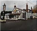
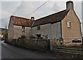
The White Hart on Wrington Road near Iwood
Image: © Roger Cornfoot
Taken: 9 Dec 2016
0.18 miles
4
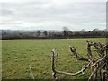
From the Wrington Road - typical farmland
Looking South West across grid square. The western reaches of the Mendip Hills can be seen in the distance.
Image: © FollowMeChaps
Taken: 2 Jan 2006
0.24 miles