IMAGES TAKEN NEAR TO
Pudding Pie Lane, BRISTOL, BS40 5EL
Introduction
This page details the photographs taken nearby to Pudding Pie Lane, BS40 5EL by members of the Geograph project.
The Geograph project started in 2005 with the aim of publishing, organising and preserving representative images for every square kilometre of Great Britain, Ireland and the Isle of Man.

There are currently over 7.5m images from over14,400 individuals and you can help contribute to the project by visiting https://www.geograph.org.uk
Image Map
Images are licensed for reuse under creativecommons.org/licenses/by-sa/2.0
Notes
- Clicking on the map will re-center to the selected point.
- The higher the marker number, the further away the image location is from the centre of the postcode.
Image Listing (28 Images Found)
Images are licensed for reuse under creativecommons.org/licenses/by-sa/2.0
Image
Details
Distance

2
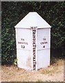
Old Milepost by the A38, Bristol Road
Cast iron post by the A38, in parish of CHURCHILL (NORTH SOMERSET District), Churchill between the WINSTON and junction with the B3133, on raised grass verge in front of garden of house, on North side of road. Bristol Trust iron casting, erected by the Bristol turnpike trust in the 19th century.
Inscription reads:-
: TO / BRISTOL / 12 : : 1837 / BRISTOL TURNPIKE TRUST : : TO / CROSS / 4 :
Grade II listed. List Entry Number: 1320944
https://historicengland.org.uk/listing/the-list/list-entry/1320944
Milestone Society National ID: SO_BRCR12.
Image: © AG Sutton
Taken: 13 Jun 2001
0.18 miles
3
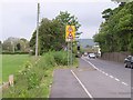
Stock Lane
The B3133 in the rush hour; a busy but narrow lane between Langford and Congresbury. A particular congestion spot is at the corner ahead, at the entrance to the School of Veterinary Science, part of the University of Bristol.
Image: © Derek Harper
Taken: 16 May 2011
0.19 miles
4
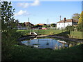
Balancing pond in Churchill
With the substantial increase in new housing in Churchill largely centred around the main Bristol Road, provision has been made for water management. This spot is at the lower end of the development and the pond is there to cope with excessive rainfall. Notably, there is no old stream in this area, just farm fields previously.
Image: © Neil Owen
Taken: 1 Oct 2021
0.20 miles
5
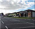
Esso, Budgens and Subway, Lower Langford
Image: © Roger Cornfoot
Taken: 16 Sep 2016
0.21 miles
9
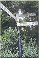
Direction Sign - Signpost by the B3133 in Langford
Pyramid finial - 3 arms; Somerset SCC pyramid by the B3133, in parish of Churchill (North Somerset District), Langford Road junction with Stock Lane, West end of Lower Langford.
Surveyed
Milestone Society National ID: SO_ST4560
Image: © Milestone Society
Taken: Unknown
0.21 miles
10
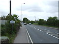
Entering Langford
Heading north east on Bristol Road (A38).
Image: © JThomas
Taken: 10 May 2013
0.21 miles