IMAGES TAKEN NEAR TO
Bloomfield Rise, BRISTOL, BS39 7TF
Introduction
This page details the photographs taken nearby to Bloomfield Rise, BS39 7TF by members of the Geograph project.
The Geograph project started in 2005 with the aim of publishing, organising and preserving representative images for every square kilometre of Great Britain, Ireland and the Isle of Man.

There are currently over 7.5m images from over14,400 individuals and you can help contribute to the project by visiting https://www.geograph.org.uk
Image Map
Images are licensed for reuse under creativecommons.org/licenses/by-sa/2.0
Notes
- Clicking on the map will re-center to the selected point.
- The higher the marker number, the further away the image location is from the centre of the postcode.
Image Listing (6 Images Found)
Images are licensed for reuse under creativecommons.org/licenses/by-sa/2.0
Image
Details
Distance
1
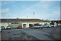
Paulton Rovers Football Club
Image: © Dominic Dawn Harry and Jacob Paterson
Taken: 18 Feb 2006
0.08 miles
2
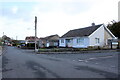
Houses on Winterfield Park
Winterfield Park is one of a number of small residential roads just off Winterfield Road, the B3355, on the southern edge of Paulton. This bungalow is at the junction with Oaklands.
Image: © Nigel Mykura
Taken: 2 Nov 2020
0.14 miles
3
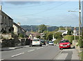
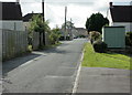
2009 : B3355 Salisbury Road, Paulton
Looking north toward the town centre.
Image: © Maurice Pullin
Taken: 10 Oct 2009
0.17 miles
4
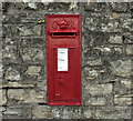
2009 : George V wall postbox, Salisbury Road, Paulton
Recently painted, neatly done.
Image: © Maurice Pullin
Taken: 10 Oct 2009
0.23 miles
5
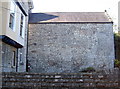
A lot of rebuilding
This large stone wall, possibly part of Plumtree (Plumtre) Farm, seems to have had an awful lot of reworking in its time, as evinced by the many lines in it.
Image: © Neil Owen
Taken: 11 Oct 2016
0.25 miles
6
2009 : Clandown Road, Paulton
Between Water Lane and Paulton Memorial Hospital.
Image: © Maurice Pullin
Taken: 10 Oct 2009
0.25 miles