IMAGES TAKEN NEAR TO
Lilian Terrace, High Street, BRISTOL, BS39 7QN
Introduction
This page details the photographs taken nearby to Lilian Terrace, High Street, BS39 7QN by members of the Geograph project.
The Geograph project started in 2005 with the aim of publishing, organising and preserving representative images for every square kilometre of Great Britain, Ireland and the Isle of Man.

There are currently over 7.5m images from over14,400 individuals and you can help contribute to the project by visiting https://www.geograph.org.uk
Image Map
Images are licensed for reuse under creativecommons.org/licenses/by-sa/2.0
Notes
- Clicking on the map will re-center to the selected point.
- The higher the marker number, the further away the image location is from the centre of the postcode.
Image Listing (39 Images Found)
Images are licensed for reuse under creativecommons.org/licenses/by-sa/2.0
Image
Details
Distance
1
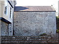
A lot of rebuilding
This large stone wall, possibly part of Plumtree (Plumtre) Farm, seems to have had an awful lot of reworking in its time, as evinced by the many lines in it.
Image: © Neil Owen
Taken: 11 Oct 2016
0.05 miles
2
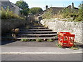
Mind how you step
A fan of steps, slightly obstructed by vegetation and some ground under repair.
Image: © Neil Owen
Taken: 11 Oct 2016
0.07 miles
3
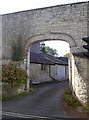
High Street arch
An unexpected arch, and possibly quite modern.
Image: © Neil Owen
Taken: 11 Oct 2016
0.09 miles
4
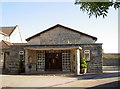
The Wesley Hall
A newer hall connected with the Methodist church close by.
Image: © Neil Owen
Taken: 11 Oct 2016
0.10 miles
5
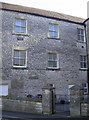
Wesleyan School
The large buildings at the top of Park Road form a group connected with the Methodist Chapel. This wall has a stone that proclaims it is the Wesleyan School of 1843. In more recent times it was the town library and information centre, but this was relocated to the Hill Court shopping centre just across the way in 2013. See Image] for the facing wall.
Image: © Neil Owen
Taken: 11 Oct 2016
0.10 miles
6
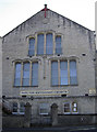
Wesleyan Chapel, 1894
The front of the chapel bears the date of 1894. However, the side of the building has a date of 1826! See Image] for a look at that.
Image: © Neil Owen
Taken: 11 Oct 2016
0.10 miles
7
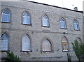
Wesleyan Chapel, 1826
This is the side wall of the main Methodist Chapel. A date stone bears the year 1826, which is rather odd. The wall to the right of shot is the school, with a date stone of 1843. However, the front of the chapel (left of shot) is dated 1894. Looking at old maps reveals there was a smaller building on this site, so perhaps the date of 1894 may be the enlargement? See Image] and Image] for the other walls.
Image: © Neil Owen
Taken: 11 Oct 2016
0.10 miles
8
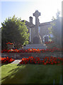
Paulton war memorial
Commemorating the town's fallen in both world wars. Interestingly, the WWI plaque faces downhill from the cross, the WWII plaque was added to the right of it, and a lone stone slab was added by the path in front of it. The latter is dedicated to Lance Sergeant Oliver Brooks, Coldstream Guards, who perished on 8th October, 1915 - doubtless a late discovery.
Image: © Neil Owen
Taken: 11 Oct 2016
0.11 miles
9
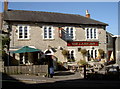
The Lamb Inn, Paulton
An old inn, probably host to hundreds of miners and printers in its time.
Image: © Neil Owen
Taken: 11 Oct 2016
0.11 miles
10
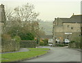
2008 : Park Road, Paulton
Copied from Wikipedia, the free encyclopedia
Paulton is a large village, population around 5,000, located to the north of the Mendip Hills, in the unitary authority of Bath and North East Somerset (BANES), England. A former coal mining village and home to the now-closed Polestar Purnells printing factory and Ashman's boot factory, where 'Tuf' boots were manufactured, Paulton is now largely populated by commuters to Bristol and Bath.
Image: © Maurice Pullin
Taken: 19 Dec 2008
0.11 miles