IMAGES TAKEN NEAR TO
Park Road, BRISTOL, BS39 7NQ
Introduction
This page details the photographs taken nearby to Park Road, BS39 7NQ by members of the Geograph project.
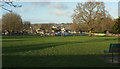
The Geograph project started in 2005 with the aim of publishing, organising and preserving representative images for every square kilometre of Great Britain, Ireland and the Isle of Man.

There are currently over 7.5m images from over14,400 individuals and you can help contribute to the project by visiting https://www.geograph.org.uk
Image Map (Loading...)


Getting Data...Please wait
Leaflet Map data © OpenStreetMap
Images are licensed for reuse under creativecommons.org/licenses/by-sa/2.0
Notes
- Clicking on the map will re-center to the selected point.
- The higher the marker number, the further away the image location is from the centre of the postcode.
Image Listing (54 Images Found)
Images are licensed for reuse under creativecommons.org/licenses/by-sa/2.0
Image
Details
Distance
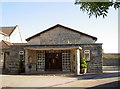
1
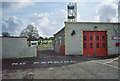
Clutton Rural District Fire Station, Paulton
Image: © Dominic Dawn Harry and Jacob Paterson
Taken: 18 Feb 2006
0.05 miles
2
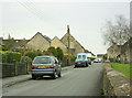
2008 : Park Road, New Town, Paulton
Seen from the entrance to the park, or amenity area.
Image: © Maurice Pullin
Taken: 19 Dec 2008
0.05 miles
3
2008 : Amenity area at New Town, Paulton
Playing fields to us though an open space here is a welcome sight.
Image: © Maurice Pullin
Taken: 19 Dec 2008
0.06 miles
4
Paulton Memorial Park
Looking right from Image], with Park Road on the right.
Image: © Derek Harper
Taken: 9 Dec 2019
0.06 miles
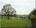
5
Paulton Memorial Park
Seen from Park Road, and showing the well-equipped play area.
Image: © Derek Harper
Taken: 9 Dec 2019
0.06 miles
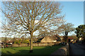
6
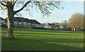
Paulton Memorial Park
Looking left from
Image: © Derek Harper
Taken: 9 Dec 2019
0.07 miles
7
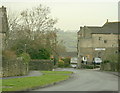
2008 : Park Road, Paulton
Copied from Wikipedia, the free encyclopedia
Paulton is a large village, population around 5,000, located to the north of the Mendip Hills, in the unitary authority of Bath and North East Somerset (BANES), England. A former coal mining village and home to the now-closed Polestar Purnells printing factory and Ashman's boot factory, where 'Tuf' boots were manufactured, Paulton is now largely populated by commuters to Bristol and Bath.
Image: © Maurice Pullin
Taken: 19 Dec 2008
0.08 miles
8
The Wesley Hall
A newer hall connected with the Methodist church close by.
Image: © Neil Owen
Taken: 11 Oct 2016
0.09 miles
9
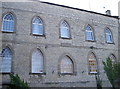
Wesleyan School
The large buildings at the top of Park Road form a group connected with the Methodist Chapel. This wall has a stone that proclaims it is the Wesleyan School of 1843. In more recent times it was the town library and information centre, but this was relocated to the Hill Court shopping centre just across the way in 2013. See Image] for the facing wall.
Image: © Neil Owen
Taken: 11 Oct 2016
0.09 miles
10
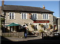
The Lamb Inn, Paulton
An old inn, probably host to hundreds of miners and printers in its time.
Image: © Neil Owen
Taken: 11 Oct 2016
0.09 miles