IMAGES TAKEN NEAR TO
Specklemead, BRISTOL, BS39 7ND
Introduction
This page details the photographs taken nearby to Specklemead, BS39 7ND by members of the Geograph project.
The Geograph project started in 2005 with the aim of publishing, organising and preserving representative images for every square kilometre of Great Britain, Ireland and the Isle of Man.

There are currently over 7.5m images from over14,400 individuals and you can help contribute to the project by visiting https://www.geograph.org.uk
Image Map (Loading...)


Getting Data...Please wait
Leaflet Map data © OpenStreetMap
Images are licensed for reuse under creativecommons.org/licenses/by-sa/2.0
Notes
- Clicking on the map will re-center to the selected point.
- The higher the marker number, the further away the image location is from the centre of the postcode.
Image Listing (24 Images Found)
Images are licensed for reuse under creativecommons.org/licenses/by-sa/2.0
Image
Details
Distance
1
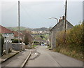
2009 : Tennis Court Road, Paulton
Coming into Paulton from Old Mills. Houses on the left have a 1950/60 look about them. The stone built houses on the right are much older.
The hills in the distance are above High Littleton.
Image: © Maurice Pullin
Taken: 16 Nov 2009
0.09 miles
2
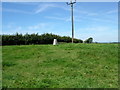
Trig Point 5330 Paulton
Photo from public footpath to the SE
Image: © Damon Knight
Taken: 11 Aug 2007
0.13 miles
3
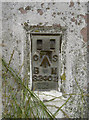
Flush bracket, Paulton
The identifying bracket on the pillar, which is still in good condition. See Image
Image: © Neil Owen
Taken: 28 Jul 2011
0.14 miles
4
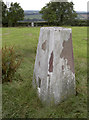
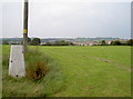
Paulton trig pillar
Placed near the summit of the field, it overlooks some great views of the surrounding countryside (see Image]) and also the Arnhem Memorial (seen in distance). The flush bracket can be found here: Image
Image: © Neil Owen
Taken: 28 Jul 2011
0.14 miles
5
Trig point near a war-time crash site
In the field just over the crest, two Horsa gliders carrying 23 men of the Royal Engineers came down in 1944. All were lost in the crash. A memorial was established nearby in 1979 - see Image] and Image] for more views.
Image: © Neil Owen
Taken: 28 Jul 2011
0.14 miles
6

Miners Welfare Recreation Ground, Paulton
The hedge left of centre borders the bowling green. Behind is a community centre. There is also a BMX track to the left of the camera.
Image: © Derek Harper
Taken: 9 Dec 2019
0.15 miles
7

That'll stop the unwanted
A striking variation on the methods of preventing cattle and motorised traffic through a field.
Image: © Neil Owen
Taken: 28 Jul 2011
0.16 miles
8

Arnhem Memorial
A poignant tribute to be found in an unremarkable field on the outskirts of Paulton, Somerset. The legend details how two gliders that were on the way to Arnhem came down here in 1944, claiming all aboard.
Also see Image], Image] and Image] for more views of the inscriptions.
Image: © Neil Owen
Taken: 28 Jul 2011
0.16 miles
9
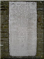
Arnhem Memorial inscription
The legend gives details of the terrible loss over home soil, shortly after taking off from RAF Keevil, only a few miles away. See Image] and Image] for more views.
Image: © Neil Owen
Taken: 28 Jul 2011
0.16 miles
10
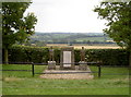
Arnhem Memorial
A memorial to the loss of 23 men of the Royal Engineers, whose gliders came down in this field in 1944. It was unveiled by Major General R.E. Urquhart C.B. D.S.O. on 23rd September, 1979, but has been improved more than once since.
Compare the picture by Damon Knight in 2006 Image The two new statues were created by SPR Roy Cleeves and installed in 2008.
See Image], Image] and Image] for more images.
Image: © Neil Owen
Taken: 28 Jul 2011
0.16 miles