IMAGES TAKEN NEAR TO
Purnell Way, BRISTOL, BS39 7AB
Introduction
This page details the photographs taken nearby to Purnell Way, BS39 7AB by members of the Geograph project.
The Geograph project started in 2005 with the aim of publishing, organising and preserving representative images for every square kilometre of Great Britain, Ireland and the Isle of Man.

There are currently over 7.5m images from over14,400 individuals and you can help contribute to the project by visiting https://www.geograph.org.uk
Image Map (Loading...)


Getting Data...Please wait
Leaflet Map data © OpenStreetMap
Images are licensed for reuse under creativecommons.org/licenses/by-sa/2.0
Notes
- Clicking on the map will re-center to the selected point.
- The higher the marker number, the further away the image location is from the centre of the postcode.
Image Listing (51 Images Found)
Images are licensed for reuse under creativecommons.org/licenses/by-sa/2.0
Image
Details
Distance
1
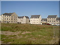
New Houses in Paulton
These houses have been built on the site of the demolished factory of Polestar Purnell the printing company.
Image: © Nigel Mykura
Taken: 18 Sep 2011
0.07 miles
2
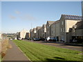
The back of Purnell Way
Once the premises of a sprawling print works post-war, this part of Paulton is now being transformed into a large housing development.
Image: © Neil Owen
Taken: 11 Oct 2016
0.09 miles
3
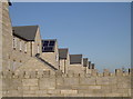
A new row of rooftops
The old printing works are now gone, along with their industrial roofs. The large housing development takes on the appearances.
Image: © Neil Owen
Taken: 11 Oct 2016
0.10 miles
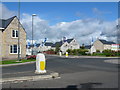
4
Church Street roundabout
Once this was the start of the massive Purnell's print works, but following the closure of Paulton's biggest employer in 2005, the old industrial buildings have been cleared and a housing estate developed in its stead.
Prior to that, in the late nineteenth century, this was the site of Manor Farm, with a boot and shoe factory just up the road. Purnell's grew in the post-WWI period, with a much larger expansion in the post-WWII.
Image: © Neil Owen
Taken: 11 Oct 2016
0.10 miles
5
Paper Lane, with a whiff of ink still in the air
An appropriate name for what was once Paulton's largest employer - Purnell's printworks used to be here, occupying several acres of land.
The company was a small family concern, established in 1839 and mainly printing bibles, but which embarked on an ambitious path of expansion, post-war. The company merged with others, buying up many other firms and moving into periodical publishing. At its peak, the company employed over 2,000 workers. However, business tailed off and the firm closed the works in 2005. Today, some of the old works land is being redeveloped into a large housing estate.
Image: © Neil Owen
Taken: 11 Oct 2016
0.11 miles
6
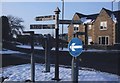
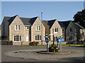
Direction Sign - Signpost on the B3355 Hallatrow Road, Paulton
Pyramid finial - 3 arms; Somerset SCC pyramid by the UC road, in parish of Paulton (Bath And North East Somerset District), in the centre of the roundabout where the B3355 Hallatrow Road, Farrington Road, Church Street and Purnell Way meet.
surveyed
Milestone Society National ID: SO_ST6456
Image: © Milestone Society
Taken: Unknown
0.11 miles
7
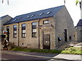
Paulton Post Office
The office appears to have served the community since the early twentieth century. You can even get your coat dry cleaned, too.
Image: © Neil Owen
Taken: 11 Oct 2016
0.11 miles
8
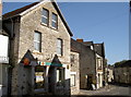
School days of the past
This is the old Parochial School, nowadays a private residential conversion. See Image] for a detail.
Image: © Neil Owen
Taken: 11 Oct 2016
0.11 miles
9
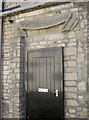
Parochial School door
This doorway, close to Holy Trinity church, is largely all that remains of the old school rooms. Education in Paulton seems to have expanded greatly in the latter part of the nineteenth century, but this one has been extensively converted into dwellings. See Image] for a wider view.
Image: © Neil Owen
Taken: 11 Oct 2016
0.11 miles
10
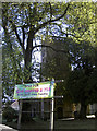
Real coffee and tea!
Holy Trinity tempts passers-by with some hot drinks.
Image: © Neil Owen
Taken: 11 Oct 2016
0.11 miles