IMAGES TAKEN NEAR TO
High Street, BRISTOL, BS39 6JE
Introduction
This page details the photographs taken nearby to High Street, BS39 6JE by members of the Geograph project.
The Geograph project started in 2005 with the aim of publishing, organising and preserving representative images for every square kilometre of Great Britain, Ireland and the Isle of Man.

There are currently over 7.5m images from over14,400 individuals and you can help contribute to the project by visiting https://www.geograph.org.uk
Image Map (Loading...)


Getting Data...Please wait
Leaflet Map data © OpenStreetMap
Images are licensed for reuse under creativecommons.org/licenses/by-sa/2.0
Notes
- Clicking on the map will re-center to the selected point.
- The higher the marker number, the further away the image location is from the centre of the postcode.
Image Listing (42 Images Found)
Images are licensed for reuse under creativecommons.org/licenses/by-sa/2.0
Image
Details
Distance
1
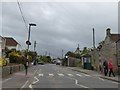
Pedestrian crossing, High Street, High Littleton
Image: © David Smith
Taken: 10 Jun 2017
0.01 miles
2
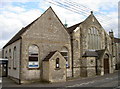
Church centre
High Littleton was a village that grew rapidly with the local coal mining industry. As with many in a similar boom, many villagers became committed with the Methodist movement. This is the northernmost of the chapels and it also offered Sunday schooling. It has now joined forces with the Holy Trinity Anglican Church to provide many varied community facilities.
Image: © Neil Owen
Taken: 6 Oct 2016
0.02 miles
3
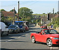
2008 : High Street, High Littleton
A view of the A39 as it passes through.
Image: © Maurice Pullin
Taken: 20 Sep 2008
0.02 miles
4
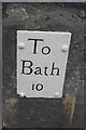
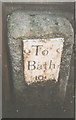
Old Milestone, A39, High Street, High Littleton
A metal plate attached to a wall behind the pavement on the east side of the road, just south of the junction with Eastover Road. Parish of High Littleton (Bath And North East Somerset District). Bath incised iron plate, erected by the Bath turnpike trust in the 18th century.
Inscription reads:
To
Bath
10
Milestone Society National ID: SO_BAGL10
Image: © Richard Raynsford
Taken: Unknown
0.04 miles
5
Old Milestone, A39, High Street, High Littleton
A metal plate attached to a wall behind the pavement on the east side of the road, just south of the junction with Eastover Road. Parish of High Littleton (Bath And North East Somerset District). Bath incised iron plate, erected by the Bath turnpike trust in the 18th century.
Inscription reads:
To
Bath
10
Milestone Society National ID: SO_BAGL10
Image: © JR Dowding
Taken: 5 Aug 2002
0.04 miles
6
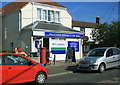
2008 : High Littleton newsagent and Post Office
And off licence.
The A39 from Bath passes the door.
Image: © Maurice Pullin
Taken: 20 Sep 2008
0.05 miles
7
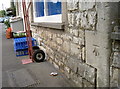
Benchmark on Dando's
An old benchmark on a shop in High Littleton, as listed in the Benchmark Database: http://www.bench-marks.org.uk/bm79463 . Also see Image] for a wider view.
Image: © Neil Owen
Taken: 6 Oct 2016
0.06 miles
8
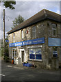
Dando's Store
At the top end of High Littleton and offering a variety of goods. See Image] for a benchmark on the corner.
Image: © Neil Owen
Taken: 6 Oct 2016
0.06 miles
9
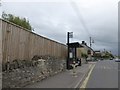
Bus stop and shelter, High Littleton
In the background is the Star Inn Image
Image: © David Smith
Taken: 10 Jun 2017
0.07 miles
10
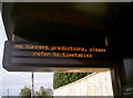
No current predictions
How modern life is enhanced by computer communications technology.
Image: © Neil Owen
Taken: 6 Oct 2016
0.08 miles