IMAGES TAKEN NEAR TO
The Mead, BRISTOL, BS39 5RF
Introduction
This page details the photographs taken nearby to The Mead, BS39 5RF by members of the Geograph project.
The Geograph project started in 2005 with the aim of publishing, organising and preserving representative images for every square kilometre of Great Britain, Ireland and the Isle of Man.

There are currently over 7.5m images from over14,400 individuals and you can help contribute to the project by visiting https://www.geograph.org.uk
Image Map (Loading...)


Getting Data...Please wait
Leaflet Map data © OpenStreetMap
Images are licensed for reuse under creativecommons.org/licenses/by-sa/2.0
Notes
- Clicking on the map will re-center to the selected point.
- The higher the marker number, the further away the image location is from the centre of the postcode.
Image Listing (47 Images Found)
Images are licensed for reuse under creativecommons.org/licenses/by-sa/2.0
Image
Details
Distance
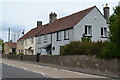
2
Beware the locals?
The sign refers to motorists using the narrow road to the school, not to the pedestrians themselves.
Image: © Neil Owen
Taken: 15 Jan 2021
0.06 miles
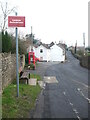
3
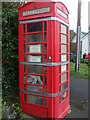
Cold calls for Covid
This community asset (an old telephone box) is now closed. Used as a library/toy store, it has now been sealed by tape to help stop infection.
Image: © Neil Owen
Taken: 15 Jan 2021
0.07 miles
4
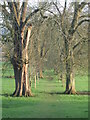
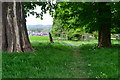
To Church Farm and the Church of St Augustine
A lovely tree-lined avenue leads from the main road down to the old church. How many worshippers would have taken this path to services over the years?
Image: © Neil Owen
Taken: 15 Jan 2021
0.11 miles
5
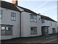
2009 : The Warwick Arms, Clutton
The A37 passes its door.
The main part of the village is to the east of the main road, a ready made bypass.
All the land in the parish of Clutton once belonged to the Earl of Warwick.
Image: © Maurice Pullin
Taken: 13 Feb 2009
0.11 miles
6
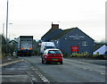
The arms have been laid down
This used to be the Warwick Arms, but is now home to the Somerset Toiletry Company (established in 1999). The pub is well over a century old but pulled its last pint in 2019.
Image: © Neil Owen
Taken: 15 Jan 2021
0.11 miles
8
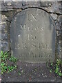
Milestone in Clutton
This stone is preserved by dint of the wall as it faces the very busy A37. Curiously, old maps show it as bearing the legend 'Bristol 9, Wells 12'. However, this one has a slightly different inscription featuring Iron Bridge, although it appears to be in the right location. Is there more of it under ground level? It should also have a benchmark on it too, but no obvious sign of that either.
See Image] for a contextual view.
Image: © Neil Owen
Taken: 15 Jan 2021
0.12 miles
9
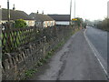
The Upper Bristol Road in Clutton
The busy A37, opposite the old Warick Arms pub of late, has a milestone in the wall. See Image] for a closer look.
Image: © Neil Owen
Taken: 15 Jan 2021
0.12 miles
10
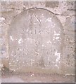
Old Milestone by the A37, Upper Bristol Road, Clutton
Carved stone post by the A37, in parish of CLUTTON (BATH AND NORTH EAST SOMERSET District), Clutton opposite Warwick Arms, embedded in stone wall, on East side of road. Bristol stone - Roman, erected by the Bristol turnpike trust in the 18th century.
Inscription reads:-
IX
Miles
To
BRISTOL
from Bridge
Milestone Society National ID: SO_BRCT09.
Image: © JR Dowding
Taken: 4 Nov 2002
0.12 miles