IMAGES TAKEN NEAR TO
Northend, BRISTOL, BS39 5QP
Introduction
This page details the photographs taken nearby to Northend, BS39 5QP by members of the Geograph project.
The Geograph project started in 2005 with the aim of publishing, organising and preserving representative images for every square kilometre of Great Britain, Ireland and the Isle of Man.

There are currently over 7.5m images from over14,400 individuals and you can help contribute to the project by visiting https://www.geograph.org.uk
Image Map (Loading...)


Getting Data...Please wait
Leaflet Map data © OpenStreetMap
Images are licensed for reuse under creativecommons.org/licenses/by-sa/2.0
Notes
- Clicking on the map will re-center to the selected point.
- The higher the marker number, the further away the image location is from the centre of the postcode.
Image Listing (12 Images Found)
Images are licensed for reuse under creativecommons.org/licenses/by-sa/2.0
Image
Details
Distance
1
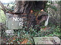
A farm that grows well
The sign for Northend Farm has been squeezed by the fruitfulness of the tree.
Image: © Neil Owen
Taken: 15 Jan 2021
0.04 miles
2
Northend Farm near Clutton
Taken from a public footpath.
Image: © John Winder
Taken: 8 Jan 2015
0.11 miles
3
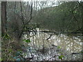
A natural pond in Fry's Bottom Wood
The old North Somerset railway line runs alongside this embankment, but at somewhat lower depth. A depression in the soil has allowed this temporary gathering, several feet above the old trackbed.
Image: © Neil Owen
Taken: 15 Jan 2021
0.12 miles
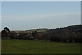
4
2010 : West from King Lane
Toward North End.
Image: © Maurice Pullin
Taken: 5 Jul 2010
0.12 miles
5
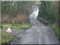
Trouble on King Lane
Flood warnings for the dip in the road as it crosses the old railway line. It seems odd that the waters congregate here as the bridge is quite a height above the trackbed.
Image: © Neil Owen
Taken: 15 Jan 2021
0.12 miles
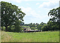
6
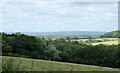
2010 : East from Lower Bristol Road
Between Breach and North End.
The line of the former North Somerset Railway is on the far side of this field, the woods beyond it hide a long gone coal mine.
Image: © Maurice Pullin
Taken: 5 Jul 2010
0.13 miles
7
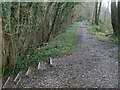
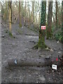
Dropping down to cross the old track
The North Somerset railway used to run through Fry's Bottom Wood. Now ripped up the track can be crossed by a footpath that has some handy steps to negotiate the embankment.
Image: © Neil Owen
Taken: 15 Jan 2021
0.13 miles
8
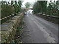
The old railway bridge on King Lane
The old North Somerset railway used to pass through Fry's Bottom Wood and under this bridge until its closure in the 1950s. A rivet benchmark can be found on the north parapet - see Image
Image: © Neil Owen
Taken: 15 Jan 2021
0.14 miles
9
This is the end
Part of the old railway line now appears to be an outdoor activity area. Whoever uses it must like mud.
Image: © Neil Owen
Taken: 15 Jan 2021
0.14 miles
10
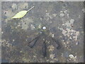
King Lane bridge benchmark
A rivet benchmark lies on the old railway bridge on King Lane. See https://www.bench-marks.org.uk/bm139425 for the entry in the Benchmark Database and Image] for a wider view.
Image: © Neil Owen
Taken: 15 Jan 2021
0.14 miles