IMAGES TAKEN NEAR TO
Eastcourt Road, BRISTOL, BS39 5BT
Introduction
This page details the photographs taken nearby to Eastcourt Road, BS39 5BT by members of the Geograph project.
The Geograph project started in 2005 with the aim of publishing, organising and preserving representative images for every square kilometre of Great Britain, Ireland and the Isle of Man.

There are currently over 7.5m images from over14,400 individuals and you can help contribute to the project by visiting https://www.geograph.org.uk
Image Map
Images are licensed for reuse under creativecommons.org/licenses/by-sa/2.0
Notes
- Clicking on the map will re-center to the selected point.
- The higher the marker number, the further away the image location is from the centre of the postcode.
Image Listing (19 Images Found)
Images are licensed for reuse under creativecommons.org/licenses/by-sa/2.0
Image
Details
Distance
1
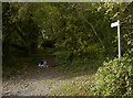
Where there'a path, there's rubbish
An all too common sight. This little pile contained, amongst other stuff, an old office chair and a fire extinguisher.
Image: © Neil Owen
Taken: 23 Oct 2018
0.03 miles
2
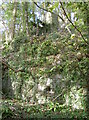
Quarrying remnants
Some old ironmongery, high above the track - presumably part of the former quarrying activities here.
Image: © Neil Owen
Taken: 23 Oct 2018
0.04 miles
3
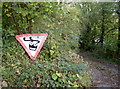
Looking at things differently
A rather striking use of a standard road sign. Hopefully no motorists have fallen off the road.
Image: © Neil Owen
Taken: 23 Oct 2018
0.04 miles
4
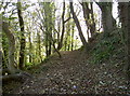
Stepped quarrying
The land here was quite extensively quarried, with much of the stone going to construct the Clutton Union Workhouse just over the road.
Image: © Neil Owen
Taken: 23 Oct 2018
0.06 miles
5
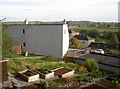
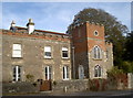
Allotments on the old union house
This view takes in part of what remains of the Clutton Union Workhouse, in Eastcourt Road. It had a varied history: originally contracted to be constructed in 1836-7 at a cost of £4,695 it provided beds for up to 400 inmates, and offered school and infirmary facilities. Locally quarried stone was used on this steeply sloping land to build it and it formally opened towards the end of 1837.
The institution took in many and varied poor souls - from local unmarried mothers, injured (and therefore unpaid) farm labourers and those with other health issues. Following the end of hostilities in 1918-19, there were also several vagrant soldiers and sailors who found the return to civilian life difficult.
The Ministry of Health took over the running in 1919, until the whole Poor Law acts were wound up in 1930. Somerset County Council then tok the site over as a Public Assistance Institution until that too closed on 7th June, 1967. It is now private residences.
See http://www.highlittletonhistory.org.uk/transcriptions0905/CluttonUnionWorkhouseDeaths1838-1927&Indx.pdf for a longer history.
Image: © Neil Owen
Taken: 23 Oct 2018
0.10 miles
6
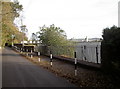
Eastcourt Road
Looking along the side of what was the former Cambrook House, a Somerset County Council office.
Image: © Neil Owen
Taken: 23 Oct 2018
0.10 miles
7
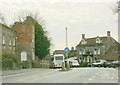
2008 : The town of Temple Cloud
Where Cameley Road joins the A37.
Do you know the difference between a town and a village? The following was copied from http://www.british-towns.net/en/level_4_display.asp?GetL3=9818 and may clear up a few points. Good one webmaster, an interesting website.
"The town of Temple Cloud is an urban area that is larger than a village but smaller than a city. Unless Temple Cloud grows to a size where it is elevated to a higher administrative status it is effectively a parish but to differentiate between the two at the turn of the last century towns were granted the right to allow their elected representatives call themselves a "Town Council" and to, from their number, elect a Mayor. Other than that they have the same legal rights and responsibilities as a Parish Council."
There is more.
A road (classified A)
Image: © Maurice Pullin
Taken: 19 Dec 2008
0.17 miles
9
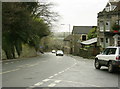
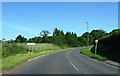
2008 : The A37 at Temple Cloud
Coming up the hill from Temple Bridge the A37 is just entering Temple Cloud on its way to Pensford and Bristol.
The viewpoint is at the junction with Cameley Road.
Image: © Maurice Pullin
Taken: 19 Dec 2008
0.18 miles
10
The Refuge
A particularly interesting old building in Temple Cloud: it is believed to have sixteenth century foundations, starting as the Bell Inn, and having several changes of owner and styles since then!
Image: © Neil Owen
Taken: 23 Oct 2018
0.22 miles