IMAGES TAKEN NEAR TO
Hook Lane, BRISTOL, BS39 5BB
Introduction
This page details the photographs taken nearby to Hook Lane, BS39 5BB by members of the Geograph project.
The Geograph project started in 2005 with the aim of publishing, organising and preserving representative images for every square kilometre of Great Britain, Ireland and the Isle of Man.

There are currently over 7.5m images from over14,400 individuals and you can help contribute to the project by visiting https://www.geograph.org.uk
Image Map (Loading...)


Getting Data...Please wait
Leaflet Map data © OpenStreetMap
Images are licensed for reuse under creativecommons.org/licenses/by-sa/2.0
Notes
- Clicking on the map will re-center to the selected point.
- The higher the marker number, the further away the image location is from the centre of the postcode.
Image Listing (11 Images Found)
Images are licensed for reuse under creativecommons.org/licenses/by-sa/2.0
Image
Details
Distance
1
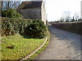
Hook Lane
A minor road leading south from Hinton Blewett. See Image] for a look at an inn trail marker handily placed.
Image: © Neil Owen
Taken: 7 Mar 2016
0.13 miles
2
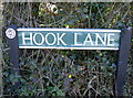
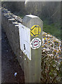
Hook Lane
Note the small trail sign: it's a pub trail that takes in several of the inns owned by Butcombe Brewery. Their Mendip Pub Trail includes the Ring o' Bells in Hinton Blewett. See Image] for a wider view.
Image: © Neil Owen
Taken: 7 Mar 2016
0.14 miles
3
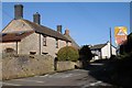
Lower Road, Hinton Blewett
Houses on Lower Road in Hinton Blewett.
Image: © Philip Halling
Taken: 15 Feb 2018
0.14 miles
4
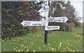
Direction Sign - Signpost on the southwest side of Sutton Hill Road and Lower Road
Pyramid finial - 4 arms, 1 missing; Somerset SCC pyramid by the UC road, in parish of Hinton Blewett (Bath And North East Somerset District), on the southwest side of the T on the southwest side of Sutton Hill Road and Lower Road.
surveyed
Milestone Society National ID: SO_ST5956B
Image: © Milestone Society
Taken: Unknown
0.18 miles
5
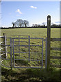
Away across the fields
A footpath takes walkers on to either Sedbrook Farm or towards Coley Upper Reservoir.
Image: © Neil Owen
Taken: 7 Mar 2016
0.18 miles
6
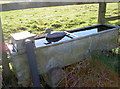
Waterfowl decoy?
A plastic quacker, floating on a water trough.
Image: © Neil Owen
Taken: 7 Mar 2016
0.18 miles
7
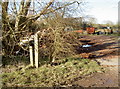
Footpath this way, pub path that way
A fire hydrant post (with a very faded stick-on sign over the original yellow plate) also provides directions for travellers. One is a conventional arrow for an official footpath, the other is courtesy of Butcombe Brewery. They have produced a 45 mile (72km) trail that links several of their owned inns in Somerset, one of which is the Ring o' Bells in Hinton Blewett.
Just make sure you know which one you want to follow.
Image: © Neil Owen
Taken: 7 Mar 2016
0.18 miles
8
Through the farm yard
A choice of paths, this one goes through Combe Hill Farm, to the south of Hinton Blewett and on to the village hall.
Image: © Neil Owen
Taken: 7 Mar 2016
0.18 miles
9
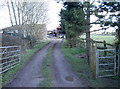
Path to Combe Hill Farm
A footpath takes walkers from the main road in the village and out towards a path junction.
Image: © Neil Owen
Taken: 7 Mar 2016
0.19 miles
10
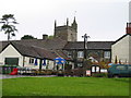
Ring O Bells Pub, Hinton Blewitt
Image: © Stuart and Fiona Jackson
Taken: 23 May 2005
0.23 miles