IMAGES TAKEN NEAR TO
Stanton Drew, BRISTOL, BS39 4WP
Introduction
This page details the photographs taken nearby to BS39 4WP by members of the Geograph project.
The Geograph project started in 2005 with the aim of publishing, organising and preserving representative images for every square kilometre of Great Britain, Ireland and the Isle of Man.

There are currently over 7.5m images from over14,400 individuals and you can help contribute to the project by visiting https://www.geograph.org.uk
Image Map (Loading...)


Getting Data...Please wait
Leaflet Map data © OpenStreetMap
Images are licensed for reuse under creativecommons.org/licenses/by-sa/2.0
Notes
- Clicking on the map will re-center to the selected point.
- The higher the marker number, the further away the image location is from the centre of the postcode.
Image Listing (116 Images Found)
Images are licensed for reuse under creativecommons.org/licenses/by-sa/2.0
Image
Details
Distance
1
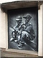
Taking a rest from the toil
A mural of miners has been created on the side of, appropriately, the old miners' welfare institute. Pensford employed many men in the coal mines in the nineteenth century. A similar image can be found on the George and Dragon on the High Street nearby - see Image
Image: © Neil Owen
Taken: 5 Mar 2021
0.02 miles
2
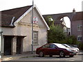
Institute - to let
The old Pensford miners had a tough enough existence and so this welfare institute was founded in 1906. Today, however, the social club has vacated the premises and is offering the building for sale.
Image: © Neil Owen
Taken: 28 Jul 2011
0.02 miles
3
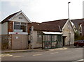
Pensford bus stop
Right outside the old Miners' Welfare Institute.
Image: © Neil Owen
Taken: 28 Jul 2011
0.02 miles
4
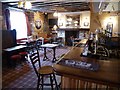
The bar of The Rising Sun
We had a nice pub lunch in The Rising Sun and whilst no one was in the bar I managed to take this picture. It's good to see an traditional unspoilt pub retaining its character.
Image: © Philip Halling
Taken: 11 Aug 2017
0.02 miles
5
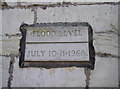
The Great Flood of '68
Pensford was devastated in the terrible flooding of the River Chew in 1968, with the main bridge being washed away, the railway viaduct and St Thomas à Becket church becoming weakened to the point of disuse and many properties extensively damaged. This marker is on a former mill close to the centre of the village - see Image
Image: © Neil Owen
Taken: 3 Oct 2016
0.02 miles
6
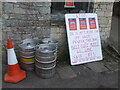
'Du U Af Two Bee Ear?'
Some sage advice to passers-by, if not quite top notch scholarly work. The beer barrels are suspicious by inclusion.
Image: © Neil Owen
Taken: 5 Mar 2021
0.02 miles
7
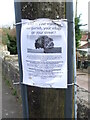
What is your vision?
Publow with Pensford Parish Council have declared a Climate Emergency! They now want to hear what locals have in mind for the response, be it via social media, letters, phone calls, artworks or songs.
Image: © Neil Owen
Taken: 5 Mar 2021
0.03 miles
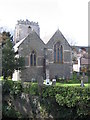
8
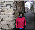
Flood Level at Pensford 10th and 11th July 1968
The level is shown on the plaque on the wall top left. Part of Pensford viaduct is also shown. Bristol and North Somerset Railway, built the viaduct in 1873 but closed to trains in 1968 after the flood made it supposedly unsafe.
Image: © Rick Crowley
Taken: 18 Feb 2009
0.03 miles
10
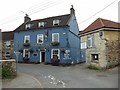
The Rising Sun, Pensford
An unspoilt traditional pub with character.
Image: © Philip Halling
Taken: 11 Aug 2017
0.03 miles