IMAGES TAKEN NEAR TO
Codrington, Chipping Sodbury, BRISTOL, BS37 6SA
Introduction
This page details the photographs taken nearby to BS37 6SA by members of the Geograph project.
The Geograph project started in 2005 with the aim of publishing, organising and preserving representative images for every square kilometre of Great Britain, Ireland and the Isle of Man.

There are currently over 7.5m images from over14,400 individuals and you can help contribute to the project by visiting https://www.geograph.org.uk
Image Map
Images are licensed for reuse under creativecommons.org/licenses/by-sa/2.0
Notes
- Clicking on the map will re-center to the selected point.
- The higher the marker number, the further away the image location is from the centre of the postcode.
Image Listing (9 Images Found)
Images are licensed for reuse under creativecommons.org/licenses/by-sa/2.0
Image
Details
Distance
1
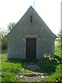
Utility building on Claypit Hill
The lintel bears the name W.C.W. Company. As it is on the top of the hill it may possibly a water facility.
Image: © Neil Owen
Taken: 19 Apr 2021
0.07 miles
2
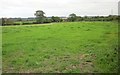
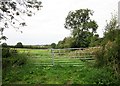
Field by Dodington Lane
The field is shown in Image] from a gate across in the centre of this image; the tall tree can be seen in both. In the background is Image
Image: © Derek Harper
Taken: 27 Sep 2014
0.08 miles
3
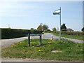
Road junction on Claypit Hill
The tiny patch of greenery now has dandelions to brighten it up as the daffs have gone over.
Image: © Neil Owen
Taken: 19 Apr 2021
0.08 miles
4
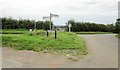
Road junction at top of Claypit Hill
Claypit Hill is the road to the road, dropping towards Chipping Sodbury. The parish boundary between Dodington (left) and Sodbury, which has followed Dodington Lane (foreground), follows Claypit Hill. A glimpse of Yate through the gateway ahead.
Image: © Derek Harper
Taken: 27 Sep 2014
0.09 miles
5
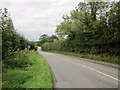
Claypit Hill
The road from Wapley drops towards Chipping Sodbury.
Image: © Derek Harper
Taken: 27 Sep 2014
0.15 miles
6
Field by Dodington Lane
Left of centre, just discernible in the distance, is the church tower at Chipping Sodbury.
Image: © Derek Harper
Taken: 27 Sep 2014
0.16 miles
7
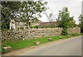
House on Dodington Lane
Great Kingley Cottage is close to where footpath LSO/36 meets the lane.
Image: © Derek Harper
Taken: 27 Sep 2014
0.18 miles
8
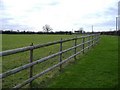
Mowswell farm
An isolated farm, south of Chipping Sodbury.
Image: © Roger Cornfoot
Taken: 27 Jan 2007
0.18 miles
9
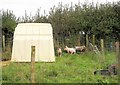
Piglets near Chipping Sodbury
Facing every which way beside footpath LSO/36.
Image: © Derek Harper
Taken: 27 Sep 2014
0.20 miles