IMAGES TAKEN NEAR TO
Cooks Lane, BRISTOL, BS36 2UR
Introduction
This page details the photographs taken nearby to Cooks Lane, BS36 2UR by members of the Geograph project.
The Geograph project started in 2005 with the aim of publishing, organising and preserving representative images for every square kilometre of Great Britain, Ireland and the Isle of Man.

There are currently over 7.5m images from over14,400 individuals and you can help contribute to the project by visiting https://www.geograph.org.uk
Image Map
Images are licensed for reuse under creativecommons.org/licenses/by-sa/2.0
Notes
- Clicking on the map will re-center to the selected point.
- The higher the marker number, the further away the image location is from the centre of the postcode.
Image Listing (19 Images Found)
Images are licensed for reuse under creativecommons.org/licenses/by-sa/2.0
Image
Details
Distance
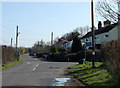
1
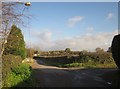
Junction, Henfield
The Hollows passes Cooks Lane on the right.
Image: © Derek Harper
Taken: 22 Nov 2013
0.03 miles
2
Junction, Henfield
The T junction shown in Image], seen from Cooks Lane.
Image: © Derek Harper
Taken: 22 Nov 2013
0.04 miles
3
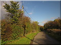
Cooks Lane
A tiny little lane at Henfield, linking The Hollows to the busy Westerleigh Road.
Image: © Derek Harper
Taken: 22 Nov 2013
0.07 miles
4
Cooks Lane
Looking in the other direction to Image
Image: © Derek Harper
Taken: 22 Nov 2013
0.07 miles
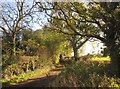
5
The Hollows
The lane just past Henfield Farm.
Image: © Derek Harper
Taken: 22 Nov 2013
0.11 miles
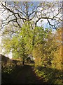
6
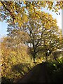
Cooks Lane
Further southeast along the little lane shown in Image], with autumnal oaks.
Image: © Derek Harper
Taken: 22 Nov 2013
0.11 miles
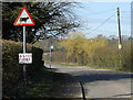
7
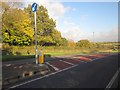
Westerleigh Road at Henfield
With a pedestrian refuge, useful on this busy if unclassified road, at the location where Image] was taken.
Image: © Derek Harper
Taken: 22 Nov 2013
0.16 miles
8
2011 : Henfield, at the bottom of Ram Hill
Henfield is situated near the centre of the North Bristol Coal Field, this area at one time having been a prolific coal mining community. Coal had been mined in this area since the fourteenth century and most likely even earlier. However it was Sir Samuel Astry, Lord of the Manor of Westerleigh c1680 who started mining on a grander scale and his descendants, or their business partners, continued to be connected with the Coalpit Heath Colliery Company.
Within Henfield itself there were 4 mines operational in the early nineteenth century:
Copied from: http://en.wikipedia.org/wiki/Henfield,_Gloucestershire where there is much more.
Image: © Maurice Pullin
Taken: 20 Mar 2011
0.17 miles
9
2011 : Slow Farmer near Rogers Farm
No point rushing around, cows don't milk faster, corn don't grow quicker. Can't be fussed with all this faffing around.
At least he was fast enough to get out of the way of my C1. Good thing too, could have made a nasty mess on my windscreen.
Image: © Maurice Pullin
Taken: 20 Mar 2011
0.18 miles
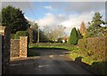
10
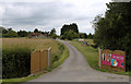
2011 : Entrance to Henfield Farm
Didn't know you could buy models off the shelf like that ... Oh! I see, it's the gift vouchers.
Not many farms have a welcoming entrance, was tempted but had more geographs to take.
Image: © Maurice Pullin
Taken: 20 Jun 2011
0.20 miles