IMAGES TAKEN NEAR TO
Badminton Road, BRISTOL, BS36 2NL
Introduction
This page details the photographs taken nearby to Badminton Road, BS36 2NL by members of the Geograph project.
The Geograph project started in 2005 with the aim of publishing, organising and preserving representative images for every square kilometre of Great Britain, Ireland and the Isle of Man.

There are currently over 7.5m images from over14,400 individuals and you can help contribute to the project by visiting https://www.geograph.org.uk
Image Map
Images are licensed for reuse under creativecommons.org/licenses/by-sa/2.0
Notes
- Clicking on the map will re-center to the selected point.
- The higher the marker number, the further away the image location is from the centre of the postcode.
Image Listing (7 Images Found)
Images are licensed for reuse under creativecommons.org/licenses/by-sa/2.0
Image
Details
Distance
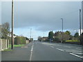
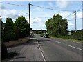
1
2012 : A432 Badminton Road at Coalpit Heath
The South Gloucestershire Coalfield was closed around 1950 but Coalpit Heath still has a Miners Social Club http://cphvh.webs.com/silverlining.htm
Image: © Maurice Pullin
Taken: 2 Apr 2012
0.04 miles
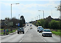
3
2012 : A432 entering Coalpit Heath from the north east
Due to recent development it is now difficult to tell where Coalpit Heath begins and Frampton Cotterell to the north west ends.
"[Coalpit Heath] was founded as a coal mining settlement. One pit was on Frog Lane at ST 685 815 (to the north east of the village). Other mines operated between Mays Hill and Nibley to the north and at Ram Hill and Henfield to the south. These were served by a railway line, closed some decades ago and no longer visible on the ground. In 1949 the coal ran out, and since then it has become a sought after place to live, with fields and easy accommodation."
The above was copied from: http://en.wikipedia.org/wiki/Coalpit_Heath
Image: © Maurice Pullin
Taken: 2 Apr 2012
0.15 miles
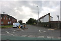
5
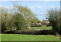
2012 : Farm land and goods depot, Frog Lane
North east of Coalpit Heath.
Seen from the A432 Badminton Road.
Image: © Maurice Pullin
Taken: 2 Apr 2012
0.18 miles
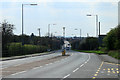
6
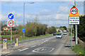
2012 : A432 Badminton Road leaving Coalpit Heath
Heading north east to Yate and Chipping Sodbury.
Image: © Maurice Pullin
Taken: 2 Apr 2012
0.23 miles