IMAGES TAKEN NEAR TO
Middle Leaze, BS36 2FZ
Introduction
This page details the photographs taken nearby to Middle Leaze, BS36 2FZ by members of the Geograph project.
The Geograph project started in 2005 with the aim of publishing, organising and preserving representative images for every square kilometre of Great Britain, Ireland and the Isle of Man.

There are currently over 7.5m images from over14,400 individuals and you can help contribute to the project by visiting https://www.geograph.org.uk
Image Map
Images are licensed for reuse under creativecommons.org/licenses/by-sa/2.0
Notes
- Clicking on the map will re-center to the selected point.
- The higher the marker number, the further away the image location is from the centre of the postcode.
Image Listing (10 Images Found)
Images are licensed for reuse under creativecommons.org/licenses/by-sa/2.0
Image
Details
Distance
3
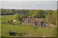
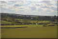
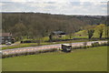
Evening sun on fields at Woodlands Farm
Image: © Steve Daniels
Taken: 20 Feb 2013
0.15 miles
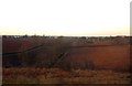
5
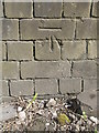
Coalpit Heath viaduct benchmark
A crisp and clear cutmark on the mighty buttress of the railway viaduct. See https://www.bench-marks.org.uk/bm30635 for the entry in the Benchmark Database or Image] for a wider view of the impressive structure.
Image: © Neil Owen
Taken: 18 Apr 2019
0.19 miles
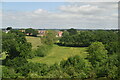
6
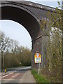
A large viaduct to welcome visitors to Coalpit Heath
A mighty tall and substantial viaduct straddles the road to the village. A benchmark has been cut into the foot of the brickwork behind the sign - see Image
Image: © Neil Owen
Taken: 18 Apr 2019
0.19 miles
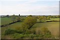
7
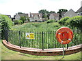
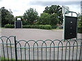
A pond in a suburban street
The very new housing development has brought with it some interesting water features, requiring safety equipment, although there does not appear to have been any water on what was previously farmland.
Image: © Neil Owen
Taken: 9 Jul 2021
0.21 miles
10
Basketball court by St Saviour's Rise
A patch of open greenery is partly given over to outdoor sport, albeit that the court is a double-circle design.
Image: © Neil Owen
Taken: 9 Jul 2021
0.25 miles