IMAGES TAKEN NEAR TO
Old Gloucester Road, BRISTOL, BS36 1RU
Introduction
This page details the photographs taken nearby to Old Gloucester Road, BS36 1RU by members of the Geograph project.
The Geograph project started in 2005 with the aim of publishing, organising and preserving representative images for every square kilometre of Great Britain, Ireland and the Isle of Man.

There are currently over 7.5m images from over14,400 individuals and you can help contribute to the project by visiting https://www.geograph.org.uk
Image Map
Images are licensed for reuse under creativecommons.org/licenses/by-sa/2.0
Notes
- Clicking on the map will re-center to the selected point.
- The higher the marker number, the further away the image location is from the centre of the postcode.
Image Listing (9 Images Found)
Images are licensed for reuse under creativecommons.org/licenses/by-sa/2.0
Image
Details
Distance
2

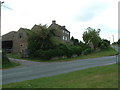
Barns at Brickhouse Farm
Agricultural buildings just south of Frogland Cross on the B4427.
Image: © Ruth Riddle
Taken: 31 Dec 2011
0.06 miles
3
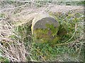
Old Milestone by the B4427, Old Gloucester Road, Frampton Cotterell Parish
Stone post (plate lost) by the B4427, in parish of FRAMPTON COTTERELL (SOUTH GLOUCESTERSHIRE District), Old Gloucester Road, between Frogland Cross and Brickhouse Farm, on deep verge, on West side of road. Erected by the Bristol turnpike trust in the 19th century.
Inscription once read:- : (Bristol / 8) :
Milestone Society National ID: GL_BREG08.
Image: © M Faherty
Taken: 29 Mar 2014
0.07 miles
6
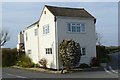
Tollhouse by the B4427 at Froglands Cross, Frampton Cotterell
Tollhouse by the B4427, in parish of Frampton Cotterell (South Gloucestershire District), Turnpike House, Froglands Cross, at the junction of Old Gloucester Road and Gaunts Earthcott Lane, BS36 1RU.
Surveyed
Milestone Society National ID: AV.FRA
Image: © Alan Rosevear
Taken: 29 Mar 2014
0.21 miles
7
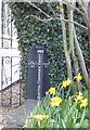
Old Boundary Marker by the B4427, Frogland Cross
Parish Boundary Marker - Turnpike by the B4427, in parish of Frampton Cotterell (South Gloucestershire District), by Turnpike House, Frogland Cross, Old Gloucester Road, Gaunt's Earthcott, beside porch, side gate, and flower bed.
Inscription reads:-
: FRN.COTL. / PH. : : 1827 / BRISTOL TURNPIKE TRUST. : : ALVESTN. / PH. :
South Gloucestershire HER.
HER number: 15172 https://www.heritagegateway.org.uk/Gateway/Results_Single.aspx?uid=15172&resourceID=111
Surveyed
Milestone Society National ID: GL_BREG08pb
Image: © Alan Rosevear
Taken: 19 Mar 2014
0.21 miles
8

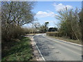
Gas pipeline adjacent to the B4427, the Old Gloucester Road
Image: © Dr Duncan Pepper
Taken: 4 Jun 2013
0.21 miles
9

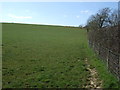
Cattle grazing pasture below Brickhouse Farm, Old Gloucester Road
Image: © Dr Duncan Pepper
Taken: 4 Jun 2013
0.21 miles