IMAGES TAKEN NEAR TO
Bradley Avenue, BRISTOL, BS36 1HU
Introduction
This page details the photographs taken nearby to Bradley Avenue, BS36 1HU by members of the Geograph project.
The Geograph project started in 2005 with the aim of publishing, organising and preserving representative images for every square kilometre of Great Britain, Ireland and the Isle of Man.

There are currently over 7.5m images from over14,400 individuals and you can help contribute to the project by visiting https://www.geograph.org.uk
Image Map (Loading...)


Getting Data...Please wait
Leaflet Map data © OpenStreetMap
Images are licensed for reuse under creativecommons.org/licenses/by-sa/2.0
Notes
- Clicking on the map will re-center to the selected point.
- The higher the marker number, the further away the image location is from the centre of the postcode.
Image Listing (14 Images Found)
Images are licensed for reuse under creativecommons.org/licenses/by-sa/2.0
Image
Details
Distance
1
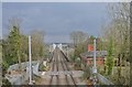
Winterbourne railway station (site), Gloucestershire
Opened in 1903 by the Great Western Railway on the line from Swindon to the Severn Tunnel, this station closed in 1963.
View east towards Coalpit Heath and Swindon, as the electrification masts were going up.
Image: © Nigel Thompson
Taken: 31 Mar 2018
0.13 miles
2
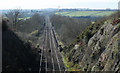
2011 : Railway from the overbridge on Dragon Road
Looking east along the line built by the GWR to make a more direct route between Paddington and South Wales via the Severn Tunnel. Avoids the loop south via Bath and Bristol, joining the main line south of Wootton Bassett.
Image: © Maurice Pullin
Taken: 20 Mar 2011
0.13 miles
3
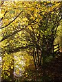
Huckford Viaduct from Ivory Hill
A detail of the scene in Image], with the oak tree beside the Community Forest Path.
Image: © Derek Harper
Taken: 22 Nov 2013
0.17 miles
4
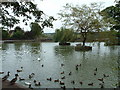
Flaxpits - The village pond at Winterbourne
View looking east over ducks expecting handouts
Image: © John Phillips
Taken: 28 Sep 2005
0.18 miles
5
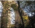
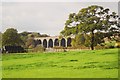
Huckford Viaduct
Image] seen through trees from the Frome Valley Walkway.
Image: © Derek Harper
Taken: 22 Nov 2013
0.20 miles
6
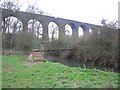
Viaduct
The 25000 series map shows the viaduct mostly in this square. The footbridge is, however, clearly in the next square to the north. The viaduct carries the trains on the line between London and Wales via Bristol Parkway 3 km away to the west.
Image: © Graham Richards
Taken: 25 Mar 2007
0.20 miles
7
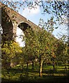
Apples below Huckford Viaduct
From the Frome Valley Walkway following footpath LWE/31, which crosses the river a few metres to the north. Sheep (you can just see one) graze the orchard. See also Image
Image: © Derek Harper
Taken: 22 Nov 2013
0.21 miles
9
River Frome below Huckford Viaduct
The Frome Valley Walkway runs beside the river as it flows between autumn trees. The reflections of the viaduct's pillar are clearer than the pillars themselves.
Image: © Derek Harper
Taken: 22 Nov 2013
0.21 miles
10
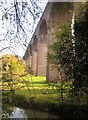
Huckford Viaduct
Seen across the River Frome from the Frome Valley Walkway. The viaduct dates from 1902, and has 11 arches http://en.wikipedia.org/wiki/Huckford_Viaduct . Sheep graze beneath.
Image: © Derek Harper
Taken: 22 Nov 2013
0.21 miles