IMAGES TAKEN NEAR TO
Itchington, Alveston, BRISTOL, BS35 3TL
Introduction
This page details the photographs taken nearby to BS35 3TL by members of the Geograph project.
The Geograph project started in 2005 with the aim of publishing, organising and preserving representative images for every square kilometre of Great Britain, Ireland and the Isle of Man.

There are currently over 7.5m images from over14,400 individuals and you can help contribute to the project by visiting https://www.geograph.org.uk
Image Map (Loading...)


Getting Data...Please wait
Leaflet Map data © OpenStreetMap
Images are licensed for reuse under creativecommons.org/licenses/by-sa/2.0
Notes
- Clicking on the map will re-center to the selected point.
- The higher the marker number, the further away the image location is from the centre of the postcode.
Image Listing (10 Images Found)
Images are licensed for reuse under creativecommons.org/licenses/by-sa/2.0
Image
Details
Distance
1
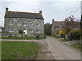
Hill Farm
The Itchington Road narrows to pass between these substantial buildings.
Image: © Jonathan Billinger
Taken: 30 Mar 2007
0.09 miles
3
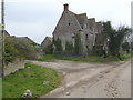
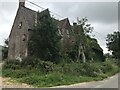
Derelict house at Manor Farm
Would be worth a fortune done up.
Image: © Jonathan Billinger
Taken: 30 Mar 2007
0.13 miles
4

South Gloucestershire : M5 Motorway
The M5 Motorway between Junction 15 (Almondsbury) and Junction 14 (Falfield).
Image: © Lewis Clarke
Taken: 30 Sep 2018
0.16 miles
5

Tytherington : M5 Motorway
The M5 Motorway between Junction 15 (Almondsbury) and Junction 14 (Falfield).
Image: © Lewis Clarke
Taken: 22 Sep 2019
0.17 miles
6

M5 crosses Itchington road
At Marker 125.5
Image: © J.Hannan-Briggs
Taken: 30 Jul 2014
0.17 miles
7
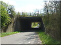
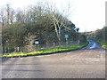
The M5 over Itchington Road
Close by the motorway is an older road, now an underpass. Some interesting geological features can be seen here - see Image
Image: © Neil Owen
Taken: 15 Apr 2021
0.19 miles
8
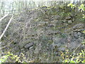
An angular unconformity
Whilst walking around the area near some large quarries, it was nevertheless a bit of a surprise to come across an information board in an otherwise anonymous stretch of road close to the motorway. It describes the geology at this spot, part of the motorway excavations, and the exposed rockface tells a particular story.
Two different layers can be seen in amongst the vegetation: the lower is Carboniferous Limestone, created some 350 million years ago when this spot was equatorial and in a shallow sea. About 280 million years ago the bed of limestone was shifted up and angled as we see today by earth movements.
Above this layer is another, namely Dolomitic Conglomerate, which was formed some 220-240 million years ago and sits on top of the limestone. Climate change as well as geographical repositioning brought about erosion of the conglomerate, which has rather smoothed over the surface. The point to note is that the two layers are separated by barely any physical distance, but are 50 million years apart. This is called an angular unconformity, and is one of the highlighted examples in Britain.
Image: © Neil Owen
Taken: 15 Apr 2021
0.20 miles
9
A tilted rockbed
According to the notice in front of this rockface, the layer of rock sloping downwards at about 45 degrees is Carboniferous Limestone, and the horizontal layer above is Dolomitic Conglomerate. The site is located adjacent to where the M5 motorway goes over Itchington Road, and it was quite surprising to find such a detailed information board sited beside this minor road.
Image: © Ruth Riddle
Taken: 7 Dec 2011
0.21 miles
10
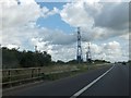
Power lines crossing the M5
On the left is a railing for the bridge over a minor road north of Itchington
Image: © David Smith
Taken: 28 Jul 2012
0.24 miles