IMAGES TAKEN NEAR TO
Foxglove Close, BRISTOL, BS35 1UG
Introduction
This page details the photographs taken nearby to Foxglove Close, BS35 1UG by members of the Geograph project.
The Geograph project started in 2005 with the aim of publishing, organising and preserving representative images for every square kilometre of Great Britain, Ireland and the Isle of Man.

There are currently over 7.5m images from over14,400 individuals and you can help contribute to the project by visiting https://www.geograph.org.uk
Image Map
Images are licensed for reuse under creativecommons.org/licenses/by-sa/2.0
Notes
- Clicking on the map will re-center to the selected point.
- The higher the marker number, the further away the image location is from the centre of the postcode.
Image Listing (15 Images Found)
Images are licensed for reuse under creativecommons.org/licenses/by-sa/2.0
Image
Details
Distance
1
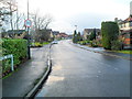
Primrose Drive, Thornbury
Viewed from the Morton Way end. Primrose Drive is the main road through an area of suburban housing in the NE of Thornbury, giving access to several cul-de-sacs.
Image: © Jaggery
Taken: 2 Jan 2012
0.06 miles
2
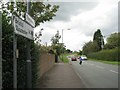
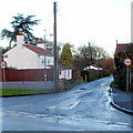
Morton Way, Thornbury
Morton Way is a perimeter road that forms the boundary to Thornbury's residential estates, on the left here. The view is north-ish from the end of Knapp Road. It continues east as Crossways Lane.
Image: © Robin Stott
Taken: 18 Sep 2010
0.06 miles
4
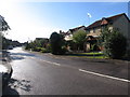
Primrose Drive houses, Thornbury
The houses are on the north side of Primrose Drive, between Morton Way and the corner of Sorrel Close. The location is at the eastern edge of Thornbury.
Image: © Jaggery
Taken: 2 Jan 2012
0.08 miles
5
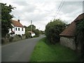
Bay Tree Cottage, Crossways Lane
Crossways Lane is the renamed length of Knapp Road between Morton Way and the old Gloucester Road.
Image: © Robin Stott
Taken: 18 Sep 2010
0.16 miles
6
Crossways Lane near Thornbury
Crossways Lane heads away from Morton Way at the eastern edge of Thornbury.
Image: © Jaggery
Taken: 2 Jan 2012
0.17 miles
8
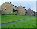
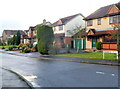
Path past Celandine Close houses, Thornbury
Viewed from Morton Way in the NE of Thornbury.
Image: © Jaggery
Taken: 2 Jan 2012
0.18 miles
9
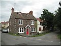
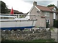
Cannon House, Hacket Lane, Thornbury: 1
At the junction with Knapp Road, in the foreground. The eye-catching decoration on the quoins and around the windows and door is applied, perhaps to brickwork, and is formed of - hazarding a guess - red slag, black cinders, and a white material, perhaps broken limestone. The grey-purple undecorated masonry looks like Old Red Sandstone - and rather weathered at that.
Image: © Robin Stott
Taken: 18 Sep 2010
0.19 miles
10
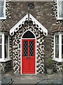
Cannon House, Hacket Lane, Thornbury: 2
At the junction with Knapp Road. The eye-catching decoration on the quoins and around the windows and door is applied, perhaps to brickwork, and is formed of - hazarding a guess - red slag, black cinders, and a white material, perhaps broken limestone. The grey-purple undecorated masonry looks like Old Red Sandstone - and rather weathered at that.
Image: © Robin Stott
Taken: 18 Sep 2010
0.19 miles