IMAGES TAKEN NEAR TO
Bramley Road, BRISTOL, BS35 1EY
Introduction
This page details the photographs taken nearby to Bramley Road, BS35 1EY by members of the Geograph project.
The Geograph project started in 2005 with the aim of publishing, organising and preserving representative images for every square kilometre of Great Britain, Ireland and the Isle of Man.

There are currently over 7.5m images from over14,400 individuals and you can help contribute to the project by visiting https://www.geograph.org.uk
Image Map
Images are licensed for reuse under creativecommons.org/licenses/by-sa/2.0
Notes
- Clicking on the map will re-center to the selected point.
- The higher the marker number, the further away the image location is from the centre of the postcode.
Image Listing (31 Images Found)
Images are licensed for reuse under creativecommons.org/licenses/by-sa/2.0
Image
Details
Distance
1
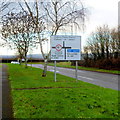
Staggered crossroads
This staggered crossroads is at the extreme northern edge of the built-up part of Thornbury, where Butt Lane and Morton Way both join the main road that heads roughly north - south through the town.
Image: © Ruth Riddle
Taken: 7 Dec 2011
0.04 miles
2
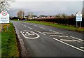
Northern boundary of Thornbury
Gloucester Road reaches Thornbury, a market town in South Gloucestershire.
The 40mph speed limit reduces to 30mph ahead.
Image: © Jaggery
Taken: 2 Jan 2012
0.05 miles
3
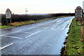
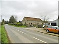
SW boundary of Upper Morton
Gloucester Road from Thornbury reaches the hamlet of Upper Morton.
Image: © Jaggery
Taken: 2 Jan 2012
0.05 miles
4
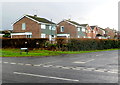
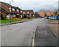
Charles Close houses, Thornbury
Viewed across Gloucester Road. Charles Close is set back from Butt Lane.
Image: © Jaggery
Taken: 2 Jan 2012
0.06 miles
5
Western end of Morton Way, Thornbury
Morton Way approaches the Gloucester Road junction at the northern edge of Thornbury.
Image: © Jaggery
Taken: 2 Jan 2012
0.09 miles
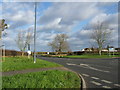
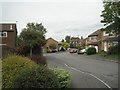
8
Swallow Park, Thornbury
A view south from the Morton Way end.
Swallow Park contains about 100 houses, located in the NE corner of Thornbury.
Image: © Jaggery
Taken: 2 Jan 2012
0.15 miles
9
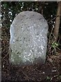
Old Milestone, Upper Morton, B4061
On the North side of the road under a hedge. Inscription is partly readable. Erected by the Bristol Turnpike Trust, probably in the 18ᵗʰ century judging by the use of Roman numerals. The distance to Gloucester is 22 miles, but unless that inscription was below ground, it probably never read it.
Inscription: XII / (Mi)les to / B(r)istol
Milestone National ID: GL_GLBRA22
Image: © Mr Red
Taken: 20 Dec 2022
0.15 miles
10
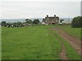
Swallow Park, Thornbury
Distant trees, centre, mark the junction with perimeter road Morton Way. A barn at Mile End Farm is just visible in the gap to the left.
Image: © Robin Stott
Taken: 18 Sep 2010
0.16 miles