IMAGES TAKEN NEAR TO
Bush Avenue, BRISTOL, BS34 8LY
Introduction
This page details the photographs taken nearby to Bush Avenue, BS34 8LY by members of the Geograph project.
The Geograph project started in 2005 with the aim of publishing, organising and preserving representative images for every square kilometre of Great Britain, Ireland and the Isle of Man.

There are currently over 7.5m images from over14,400 individuals and you can help contribute to the project by visiting https://www.geograph.org.uk
Image Map (Loading...)


Getting Data...Please wait
Leaflet Map data © OpenStreetMap
Images are licensed for reuse under creativecommons.org/licenses/by-sa/2.0
Notes
- Clicking on the map will re-center to the selected point.
- The higher the marker number, the further away the image location is from the centre of the postcode.
Image Listing (26 Images Found)
Images are licensed for reuse under creativecommons.org/licenses/by-sa/2.0
Image
Details
Distance
1
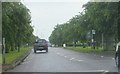
Bus stop beside the B4057
Looking eastwards along a rather rain-swept B4057 near Stoke Gifford, a bus stop and associated shelter which serve the westbound carriageway are seen to the right of the picture.
Image: © Ruth Riddle
Taken: 11 Jun 2012
0.07 miles
2
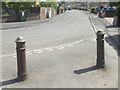
The bollards of Bush Avenue
Only two, but occupying the end of a cyclepath/footpath that is all post-WWII heritage.
Image: © Neil Owen
Taken: 30 May 2019
0.08 miles
4
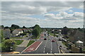
Junction of Gipsy Patch Lane and Station Road, Little Stoke
Viewed from the eastern side of the railway bridge. http://www.geograph.org.uk/photo/2156291
Ahead is Gipsy Patch Lane. Turn left into Station Road http://www.geograph.org.uk/photo/2156323 for Patchway railway station, the Civic Amenity Site, a health & leisure club, and Aretians Rugby Football Club.
Image: © Jaggery
Taken: 6 Nov 2010
0.09 miles
5
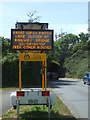
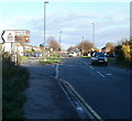
Warning of impending change
This digital traffic sign is giving fair warning of the loss of this road soon. Plans are afoot to close the bridge for demolition.
Image: © Neil Owen
Taken: 30 May 2019
0.09 miles
6
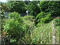
A bit of the Stoke Brook - somewhere!
The greenery has shot up in recent weeks so the little brook is difficult to see. You can just about hear its trickling above the road noise.
Image: © Neil Owen
Taken: 30 May 2019
0.11 miles
7
Railway bridge over the B4057 at Patchway
Image: © Roy Hughes
Taken: 9 Jul 2022
0.12 miles
8
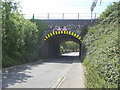
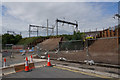
An endangered bridge
This little bridge on Gypsy Patch Lane carries the main railway line from Bristol to the Midlands. Looking at the sky, the new electrified structures hint of the modernisation of the lines that has reached the periphery of Bristol. However, the bridge is a well-known traffic pinch-point and will soon be demolished to make way for a wider one that will allow the Metrobus system to use it.
Image: © Neil Owen
Taken: 30 May 2019
0.12 miles
9
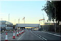
Gypsy Patch Lane Railway Bridge
The railway bridge is to be replaced as part of a Metrobus extension, and it has involved Gypsy Patch Lane being completely closed temporarily.
Image: © Bill Boaden
Taken: 10 Jul 2020
0.12 miles
10
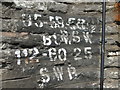
Gypsy Patch Lane railway bridge sign
A typical bridge mark, but one that is a collector's item. In a few months time it will be no more.
Image: © Neil Owen
Taken: 30 May 2019
0.13 miles