IMAGES TAKEN NEAR TO
Epney Close, BRISTOL, BS34 5NR
Introduction
This page details the photographs taken nearby to Epney Close, BS34 5NR by members of the Geograph project.
The Geograph project started in 2005 with the aim of publishing, organising and preserving representative images for every square kilometre of Great Britain, Ireland and the Isle of Man.

There are currently over 7.5m images from over14,400 individuals and you can help contribute to the project by visiting https://www.geograph.org.uk
Image Map
Images are licensed for reuse under creativecommons.org/licenses/by-sa/2.0
Notes
- Clicking on the map will re-center to the selected point.
- The higher the marker number, the further away the image location is from the centre of the postcode.
Image Listing (38 Images Found)
Images are licensed for reuse under creativecommons.org/licenses/by-sa/2.0
Image
Details
Distance
1
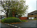
Coniston Community Centre, Patchway
Part of the northern suburban sprawl of Bristol, but situated to the south of the M5 in South Gloucestershire.
Image: © Jonathan Billinger
Taken: 4 Nov 2008
0.01 miles
2
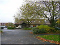
Coniston Medical Centre, Patchway
Within the northern suburban sprawl of Bristol, but situated to the south of the M5 in South Gloucestershire.
Image: © Jonathan Billinger
Taken: 4 Nov 2008
0.03 miles
3
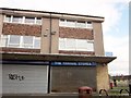
Shuttered shops, The Parade, Patchway
I was hoping to purchase a Guardian here - I know, I know. Another nearby shop was open, but had sold out of the said newspaper - well, it was nearly 3 in the afternoon. I finally tracked one down in The Mall. You can just see the postbox shown in Image
Image: © Derek Harper
Taken: 22 Feb 2014
0.06 miles
4
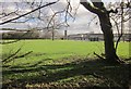
Coniston Primary School
Seen across playing fields from The Tumps.
Image: © Derek Harper
Taken: 22 Feb 2014
0.06 miles
5
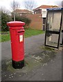
Post and telephone box, Patchway
Elizabeth II postbox number BS34 1016 is by Coniston Road near The Parade.
Image: © Derek Harper
Taken: 22 Feb 2014
0.07 miles
6
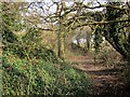
The Tumps
A small path passes some of the hillocks created from the dumping of spoil from the two railway tunnels that run beneath.
Image: © Derek Harper
Taken: 22 Feb 2014
0.09 miles
7
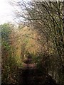
Community Forest Path near Patchway
Just east of The Tumps, but still above the railway tunnels.
Image: © Derek Harper
Taken: 22 Feb 2014
0.12 miles
8
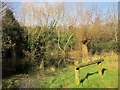
Pond, The Tumps
A pond formed in a depression among the hillocky area created from the dumping of spoil from the two railway tunnels that run beneath.
Image: © Derek Harper
Taken: 22 Feb 2014
0.13 miles
9
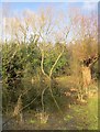
Pond, The Tumps
The willows and the pond also appear in Image], which describes The Tumps.
Image: © Derek Harper
Taken: 22 Feb 2014
0.13 miles
10
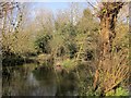
Pond, The Tumps
To accompany Image] and Image The Tumps are a hillocky wooded area created from the dumping of spoil from the two railway tunnels that run beneath.
Image: © Derek Harper
Taken: 22 Feb 2014
0.13 miles