IMAGES TAKEN NEAR TO
Derwent Close, BRISTOL, BS34 5AD
Introduction
This page details the photographs taken nearby to Derwent Close, BS34 5AD by members of the Geograph project.
The Geograph project started in 2005 with the aim of publishing, organising and preserving representative images for every square kilometre of Great Britain, Ireland and the Isle of Man.

There are currently over 7.5m images from over14,400 individuals and you can help contribute to the project by visiting https://www.geograph.org.uk
Image Map (Loading...)


Getting Data...Please wait
Leaflet Map data © OpenStreetMap
Images are licensed for reuse under creativecommons.org/licenses/by-sa/2.0
Notes
- Clicking on the map will re-center to the selected point.
- The higher the marker number, the further away the image location is from the centre of the postcode.
Image Listing (33 Images Found)
Images are licensed for reuse under creativecommons.org/licenses/by-sa/2.0
Image
Details
Distance
2
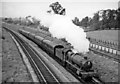
Cardiff - Bristol train near Patchway
View NW, towards the Severn Tunnel and South Wales; ex-GWR London and Bristol - South Wales main lines. The line on the right is the Up line from Patchway New Tunnel, while the train is climbing out of the original double-track tunnel and approaching Patchway station. It is headed by 4-6-0 No. 4946 'Moseley Hall' (built 8/29, withdrawn 7/63).
Image: © Ben Brooksbank
Taken: 11 Oct 1958
0.09 miles
3
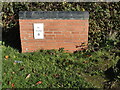
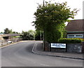
Mileplate, B4057, Patchway Roundabout
The mileplate is located on a short section of brick wall on the north side of the roundabout exit on to the B4057. The wall and mileplate were erected between October 2008 and June 2014, but the mileplate is now missing. Parish of Patchway (City of Bristol district).
Inscription reads:-
TO / Briftol / 5
Milestone Society National ID: SO_BRGL05R
Image: © Roadside Relics
Taken: 4 Nov 2020
0.10 miles
4
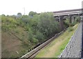
View from a Bristol-Cardiff train - bridges near Patchway
Image: © Nigel Thompson
Taken: 3 Sep 2015
0.10 miles
5
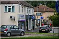
Patchway : Coniston Road
Looking towards shops off Coniston Road.
Image: © Lewis Clarke
Taken: 11 Jul 2023
0.10 miles
7
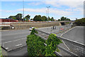
The A38 passing under the B4057
The overbridge where the B4057 joins the A38 casts a shadow onto the main road. The bus stop pictured is to the south of this, so even when the sun is low, people waiting there will not be in the shade of the roadway above.
Image: © Ruth Riddle
Taken: 6 Jan 2012
0.13 miles
9
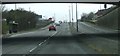
Corner of Station Road and Brookfield Road, Patchway
Brookfield Road on the left leads to The Sherrings.
The A38 Gloucester Road is at the left edge of the view, at a slightly lower level.
Image: © Jaggery
Taken: 13 May 2015
0.14 miles
10
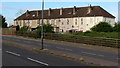
Gloucester Road chimneys, Patchway
40 metre long row of houses viewed across the A38.
Image: © Jaggery
Taken: 13 May 2015
0.14 miles