IMAGES TAKEN NEAR TO
Bickford Close, BRISTOL, BS30 8SF
Introduction
This page details the photographs taken nearby to Bickford Close, BS30 8SF by members of the Geograph project.
The Geograph project started in 2005 with the aim of publishing, organising and preserving representative images for every square kilometre of Great Britain, Ireland and the Isle of Man.

There are currently over 7.5m images from over14,400 individuals and you can help contribute to the project by visiting https://www.geograph.org.uk
Image Map (Loading...)


Getting Data...Please wait
Leaflet Map data © OpenStreetMap
Images are licensed for reuse under creativecommons.org/licenses/by-sa/2.0
Notes
- Clicking on the map will re-center to the selected point.
- The higher the marker number, the further away the image location is from the centre of the postcode.
Image Listing (10 Images Found)
Images are licensed for reuse under creativecommons.org/licenses/by-sa/2.0
Image
Details
Distance
1
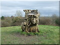
A stump that has figures and a view
This large tree stump has been left in position, carved sympathetically with creatures and also has a toposcope fitted in the centre. From this vantage point a number of distant features can be seen.
Image: © Neil Owen
Taken: 23 Feb 2021
0.18 miles
2
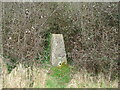
The Cock Road trig
Now set in a public open space and subject to some land management is the triangulation pillar. In the past this spot comprised plain fields with a hedge right behind where the pillar is now. That seem to have been allowed to grow a little. See Image] for the flush bracket.
Image: © Neil Owen
Taken: 23 Feb 2021
0.19 miles
3
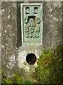
Cock Road flush bracket
This fourth order pillar bears this benchmark in the locally common 'BsM' style. See Image] for the wide view.
Image: © Neil Owen
Taken: 23 Feb 2021
0.19 miles
4
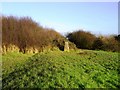
Trig Point 2316 Cockroad
Just inside the square - good views to the East
Image: © Damon Knight
Taken: 2 Jan 2007
0.20 miles
5
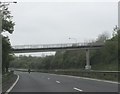
Footbridge crossing Bristol's ringroad
This footbridge allows residents of the housing estate to the south-east of the ringroad to access the open land on the other side, to the south of Cock Road.
Image: © Ruth Riddle
Taken: 4 May 2012
0.20 miles
6
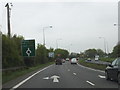
Ringroad near Cadbury Heath
Approaching a small roundabout on Bristol's ringroad near to Cadbury Heath.
Image: © Ruth Riddle
Taken: 4 May 2012
0.22 miles
7
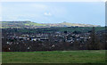
2011 : South east from the memorial park
East of Wraxall Road near Grimsbury Farm.
Looking over Cadbury Heath at the foot of the hill, Oldland is further over. Kelston Round Hill Image cannot be missed on the skyline.
Image: © Maurice Pullin
Taken: 14 Feb 2011
0.23 miles
8
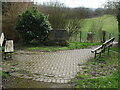
An early preacher
This little open area is at the end of Belsher Drive - a new housing development at the edge of the Cock Road Ridge green space, previously known as Mount Pleasant Great Ground. In 1812, a large house was made into the Cock Road Methodist Day School - and a Mr Belsher was one of the first ministers.
Image: © Neil Owen
Taken: 23 Feb 2021
0.24 miles
9
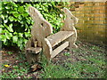
A bunny bench in Belsher Drive
The little seating area also has some benches for little legs.
Image: © Neil Owen
Taken: 23 Feb 2021
0.24 miles
10
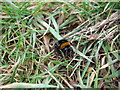
A bee bearing the brunt
It's late February and the big bees have started to emerge. Sadly this bumbler was rather torpid: looking more closely at it there are some pinkish lumps near its head - the presence of bee mites is becoming ever more common, even at this cold time of year.
Image: © Neil Owen
Taken: 23 Feb 2021
0.24 miles