IMAGES TAKEN NEAR TO
Brewery Hill, BRISTOL, BS30 6LY
Introduction
This page details the photographs taken nearby to Brewery Hill, BS30 6LY by members of the Geograph project.
The Geograph project started in 2005 with the aim of publishing, organising and preserving representative images for every square kilometre of Great Britain, Ireland and the Isle of Man.

There are currently over 7.5m images from over14,400 individuals and you can help contribute to the project by visiting https://www.geograph.org.uk
Image Map
Images are licensed for reuse under creativecommons.org/licenses/by-sa/2.0
Notes
- Clicking on the map will re-center to the selected point.
- The higher the marker number, the further away the image location is from the centre of the postcode.
Image Listing (35 Images Found)
Images are licensed for reuse under creativecommons.org/licenses/by-sa/2.0
Image
Details
Distance
1
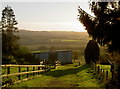
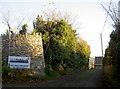
Sunshine all the way to Swineford
A late afternoon in November brings a golden vista from Upton Cheyney. A footpath invites your pleasure.
Image: © Neil Owen
Taken: 25 Nov 2016
0.01 miles
2
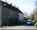
2010 : Springfield Cottages, Brewery Hill, Upton Cheyney
The site of a former brewery after which Brewery Hill was named.
Image: © Maurice Pullin
Taken: 15 Mar 2010
0.02 miles
3
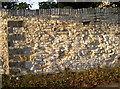
Brass among the stone
This rustic wall is mainly composed of stone, some of which has weathered a little. However, close inspection of the darker blocks show that they are slag from the brass foundries, and have a touch of copper green salts emerging.
Image: © Neil Owen
Taken: 25 Nov 2016
0.02 miles
4
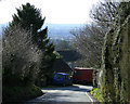
2010 : Further Down Brewery Hill, Upton Cheyney
Part of Upton Cheyney is found clinging to the side of the hill.
The view beyond is to the west, toward Keynsham and Dundry Hill.
Image: © Maurice Pullin
Taken: 15 Mar 2010
0.03 miles
5
Got the builders in
A short road to the edge of the village also carries a footpath, albeit a short one that goes about 200m.
Image: © Neil Owen
Taken: 25 Nov 2016
0.03 miles
6
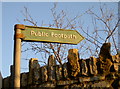
Royal path sign
This example is marked as being cast in the Royal Label Factory. See http://www.geograph.org.uk/photo/5205624 for a wider view.
Image: © Neil Owen
Taken: 25 Nov 2016
0.04 miles
7
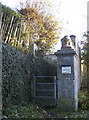
Springfield Villa path
A footpath runs alongside this residence and also features a benchmark in the pier - see Image] for a closer look.
Image: © Neil Owen
Taken: 25 Nov 2016
0.04 miles
8
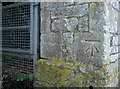
Springfield Villa benchmark
A humble cutmark, one of five in Upton Cheyney, on a pier. See http://www.bench-marks.org.uk/bm80609 for the entry in the Benchmark Database and Image] for a wider view of the footpath.
Image: © Neil Owen
Taken: 25 Nov 2016
0.05 miles
9
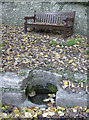
A bench and a pool
The steep Brewery Hill affords a little rest and some liquid sustenance for the weary traveller.
Image: © Neil Owen
Taken: 25 Nov 2016
0.05 miles
10
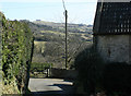
2010 : Side road at Upton Cheyney
With a view of Kelston Round Hill Image
Image: © Maurice Pullin
Taken: 15 Mar 2010
0.06 miles