IMAGES TAKEN NEAR TO
Seddon Road, BRISTOL, BS2 9YA
Introduction
This page details the photographs taken nearby to Seddon Road, BS2 9YA by members of the Geograph project.
The Geograph project started in 2005 with the aim of publishing, organising and preserving representative images for every square kilometre of Great Britain, Ireland and the Isle of Man.

There are currently over 7.5m images from over14,400 individuals and you can help contribute to the project by visiting https://www.geograph.org.uk
Image Map (Loading...)


Getting Data...Please wait
Leaflet Map data © OpenStreetMap
Images are licensed for reuse under creativecommons.org/licenses/by-sa/2.0
Notes
- Clicking on the map will re-center to the selected point.
- The higher the marker number, the further away the image location is from the centre of the postcode.
Image Listing (88 Images Found)
Images are licensed for reuse under creativecommons.org/licenses/by-sa/2.0
Image
Details
Distance
3
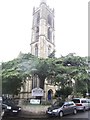
St Werburgh's Church
A former church, now a climbing centre in the St Werburghs area of central north-east Bristol. It is Grade II* listed. The church held its last service on Remembrance Sunday in 1988, after which it was deconsecrated and converted into Bristol's first indoor climbing centre called Undercover Rock. The climbing centre includes top-rope climbs, bolted lead climbs, and a bouldering area, all using hardboard walls built inside the original church structure. There is also a small cafe and viewing area.
Image: © Eirian Evans
Taken: 21 Sep 2017
0.06 miles
4
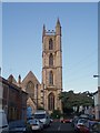
St Werburghs' Church, St Werburghs.
The 15th century St Werburghs' church originally stood in Corn Street in the centre of Bristol. It was moved to the area in 1879, and the whole district was subsequently named St Werburghs. It is now a climbing centre.
Image: © Sharon Loxton
Taken: 7 Jul 2006
0.06 miles
5
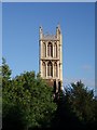
St Werburgh's Church tower.
St.Werburgh's Church was relocated stone-by-stone to Mina Road in this district from Corn Street, Bristol in 1879. The 15th century church no longer serves any religious purpose; it is now the home of the Bristol Climbing Centre and inside has 12 metre high climbing walls, pillars, fins, overhangs and arches.
See also http://www.churchcrawler.pwp.blueyonder.co.uk/swerbnew.htm
Image: © Sharon Loxton
Taken: 7 Jul 2006
0.06 miles
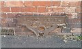
6
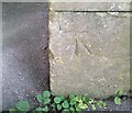
Ordnance Survey Cut Mark
This OS cut mark can be found on the west face of St Werburgh's Church. It marks a point 13.210m above mean sea level.
Image: © Adrian Dust
Taken: 9 Oct 2021
0.07 miles
8
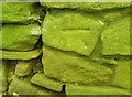
Ordnance Survey Cut Mark
This OS cut mark can be found on wall south side of the path. It marks a point 17.870m above mean sea level.
Image: © Adrian Dust
Taken: 9 Oct 2021
0.09 miles
9
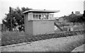
Ashley Hill Junction Signalbox
Less than ½ mile east of Montpelier Station the line heading into Bristol split at Ashley Hill Junction. The left hand route, owned by the Midland Rly (later LMSR), carried straight on to Kingswood Junction (near Fishponds) on the MR's line from Temple Meads to Gloucester & the Midlands. The right hand route curved round to Narroways Hill Junction on the GWR's line from Temple Meads to Filton & South Wales.
The junction was controlled by this modern signalbox which came into use in May 1959 replacing a much older box. It had a very short life, being taken out of use in February 1966, 5 months before the photo. The reason for its demise was the closure (in June 1965) of the line to Kingswood Junction, thus making it redundant. The track had already been removed here but its path can be made out from the empty ground at the bottom of the photo.
Image: © Martin Tester
Taken: 16 Jul 1966
0.11 miles
10
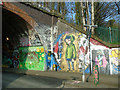
Railway tunnel, Mina Road
The southern entrance to the Mina Road tunnel leading to St Werburgh's City Farm, Bristol, made colourful by local street artists. The Narroways nature reserve runs alongside the railway above.
Image: © Carroll Pierce
Taken: 26 Mar 2017
0.11 miles