IMAGES TAKEN NEAR TO
Conduit Place, BRISTOL, BS2 9RH
Introduction
This page details the photographs taken nearby to Conduit Place, BS2 9RH by members of the Geograph project.
The Geograph project started in 2005 with the aim of publishing, organising and preserving representative images for every square kilometre of Great Britain, Ireland and the Isle of Man.

There are currently over 7.5m images from over14,400 individuals and you can help contribute to the project by visiting https://www.geograph.org.uk
Image Map
Images are licensed for reuse under creativecommons.org/licenses/by-sa/2.0
Notes
- Clicking on the map will re-center to the selected point.
- The higher the marker number, the further away the image location is from the centre of the postcode.
Image Listing (66 Images Found)
Images are licensed for reuse under creativecommons.org/licenses/by-sa/2.0
Image
Details
Distance
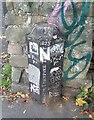
1

Ordnance Survey Cut Mark
This OS cut mark can be found on the wall SW side of Conduit Place. It marks a point 11.040m above mean sea level.
Image: © Adrian Dust
Taken: 9 Oct 2021
0.06 miles
2
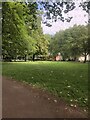
Mina Road Park
A municipal park which was laid out between 1884 and 1890. It is designed in a typical late-19th century style, with shrubberies, flower beds and a central grassed area.
Image: © Eirian Evans
Taken: 25 Jun 2023
0.07 miles
3
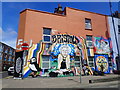
Yoga Queen
Street art on Lower Ashley Road
Image: © Eirian Evans
Taken: 30 May 2019
0.08 miles
4

Signal Controlled Junction
A sign indicating the available exits from a roundabout and advising drivers that the junction is controlled by traffic lights stands beside the B4051, Lower Ashley Road. The pavement gives access to a tunnel and the central area of the roundabout for pedestrians and cyclists.
Image: © Martin Addison
Taken: 25 Jun 2011
0.08 miles
5
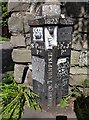
Old Boundary Marker
Turnpike Parish Boundary Marker against a stone wall beside a walkway at the end of Summers Road. On the boundary of St Paul and St Philip and St Jacob wards, Bristol. ST PAUL / PH on the left face, ST PP & JB / PH on the right face, BRISTOL TURNPIKE TRUST vertically on the front between the two with 1823 above that.
Milestone Society National ID: GL_BRIS07pb
Image: © D Dickson
Taken: 2 Sep 2019
0.09 miles
7
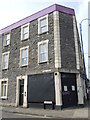
A closed corner shop
The shop at the corner of Lower Ashley Road and Tudor Road has become boarded up. For many years it was 'Teoh's' - an Oriental shop, but that closed a few years ago. Interestingly, the Chinese canopy over the door has gone but left a pitched mark on the wall. Even more interesting is the fact that the earlier occupiers name is still just readable above the door - W. E. Williams.
Image: © Neil Owen
Taken: 12 Apr 2024
0.09 miles
8
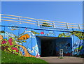
Brightening up the underpass
This underpass leads under and around the M32 at junction 3. It takes pedestrians from the St Agnes/St Pauls area towards Stapleton rd. and Easton.
Image: © Sharon Loxton
Taken: 23 Aug 2007
0.09 miles
9
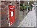
Bristol: postbox № BS2 8, Mina Road
An Edward VII-reign box, with its distinctive scroll-like cipher, set into a wall opposite the Sandbed Road turning. It is emptied finally at 5pm on weekdays and at 11:45am on Saturdays.
Image: © Chris Downer
Taken: 4 Apr 2012
0.10 miles
10
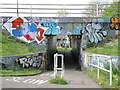
Under the M32
The M32 was built in the 1970s and took out a lot of old housing. Now the main roundabout (J3) is accessible on foot or cycle, with this a view from the inside out towards the Lower Ashley Road. Naturally, the locals have made it a part of their neighbourhood.
Image: © Neil Owen
Taken: 12 Apr 2024
0.11 miles