IMAGES TAKEN NEAR TO
High Kingsdown, BRISTOL, BS2 8EP
Introduction
This page details the photographs taken nearby to High Kingsdown, BS2 8EP by members of the Geograph project.
The Geograph project started in 2005 with the aim of publishing, organising and preserving representative images for every square kilometre of Great Britain, Ireland and the Isle of Man.

There are currently over 7.5m images from over14,400 individuals and you can help contribute to the project by visiting https://www.geograph.org.uk
Image Map
Images are licensed for reuse under creativecommons.org/licenses/by-sa/2.0
Notes
- Clicking on the map will re-center to the selected point.
- The higher the marker number, the further away the image location is from the centre of the postcode.
Image Listing (335 Images Found)
Images are licensed for reuse under creativecommons.org/licenses/by-sa/2.0
Image
Details
Distance
1
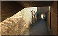
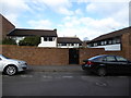
Alley, High Kingsdown
The houses at High Kingsdown were constructed in 1971-2 to a design by Anthony Mackay and won several awards. We stayed here nearly 40 years ago in a house swap.
Image: © Derek Harper
Taken: 4 Apr 2018
0.01 miles
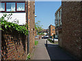
2
Terrace, Kingsdown
Further along Alfred Place from Image], with Henrietta Street on the right. All together now: "Henry must have been hungry".
Image: © Derek Harper
Taken: 4 Apr 2018
0.01 miles
3
Alfred Place, Kingsdown
Image: © Derek Harper
Taken: 4 Apr 2018
0.01 miles
4
Street corner, Kingsdown
On the left is Portland Street, on the right, Alfred Place. The building on the corner bears a plaque: "This development has been provided by Knightstone housing Association ... plaque unveiled by Lord Hylton on November 16th 1981".
Image: © Derek Harper
Taken: 4 Apr 2018
0.02 miles
5
High Kingsdown, Bristol
High Kingsdown was a prize-winning 1974 housing scheme attempting to combine high density, low rise and privacy, There are over 100 houses, with a village green - "The Square" in the middle and a pub, the King's Arms.
Image: © Eirian Evans
Taken: 20 Feb 2018
0.03 miles
6
High Kingsdown, Paul Street, Bristol
An example of the move away from high-rise concrete to low-rise housing estates in homely brick. Built 1971-75 by Whicheloe Macfarlane and JT Group Ltd. The houses are staggered so as to present a herringbone pattern from the air. A Victorian relic, the King's Arms pub, was sadly derelict at the time.
Image: © Stephen Richards
Taken: 23 May 2012
0.04 miles
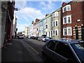
7
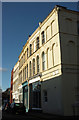
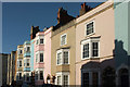
4-30 Alfred Place, Bristol
Canted bays in a Georgian terrace are unusual. The first eight houses date from c1788. Grade II listed.
The rest follow the Georgian lead but date from 1985.
Image: © Stephen Richards
Taken: 23 May 2012
0.04 miles
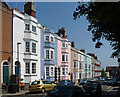
8
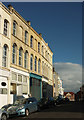
Colourful Terrace, Alfred Place
A terrace of eight mid-Georgian houses
Image: © Eirian Evans
Taken: 20 Feb 2018
0.04 miles
9
Terrace on Alfred Place, Kingsdown
Also glimpsed in Image The listed terrace is described at https://historicengland.org.uk/listing/the-list/list-entry/1201953 : "c1788 ... 2-storey canted bays, 3 storeys on Nos 16 & 26-30".
Image: © Derek Harper
Taken: 4 Apr 2018
0.04 miles
10
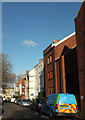
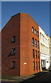
Portland Street, Kingsdown
Looking left from where Image] was taken. On the right are modern flats at Knightstone Walk; further down the street is a corner of Knightstone House, also brick, and built on the site of Portland Wesleyan Chapel, demolished in 1971. The building incorporates the gabled building, which is the former Lutton Memorial Hall (1883). On this side are three listed buildings described at https://www.historicengland.org.uk/listing/the-list/list-entry/1202451 and https://www.historicengland.org.uk/listing/the-list/list-entry/1202452 .
Down at the far end of the street is the T junction with Cotham Road.
Image: © Derek Harper
Taken: 4 Apr 2018
0.04 miles