IMAGES TAKEN NEAR TO
The Lerburne, WEDMORE, BS28 4ED
Introduction
This page details the photographs taken nearby to The Lerburne, BS28 4ED by members of the Geograph project.
The Geograph project started in 2005 with the aim of publishing, organising and preserving representative images for every square kilometre of Great Britain, Ireland and the Isle of Man.

There are currently over 7.5m images from over14,400 individuals and you can help contribute to the project by visiting https://www.geograph.org.uk
Image Map
Images are licensed for reuse under creativecommons.org/licenses/by-sa/2.0
Notes
- Clicking on the map will re-center to the selected point.
- The higher the marker number, the further away the image location is from the centre of the postcode.
Image Listing (161 Images Found)
Images are licensed for reuse under creativecommons.org/licenses/by-sa/2.0
Image
Details
Distance
1
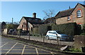
Former gas works, Wedmore
Off The Lerburne. Beyond The Old Gas Works Cottage is The Retort House. "The Wedmore Gas Company built a private gas works in 1868. The gas works ceased to make gas in 1947" http://webapp1.somerset.gov.uk/her/details.asp?prn=12545 .
Image: © Derek Harper
Taken: 25 Mar 2016
0.00 miles
2
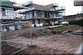
New house building
Several homes are being built in the former farmyard
Image: © Bob Harvey
Taken: 12 Oct 2019
0.03 miles
3
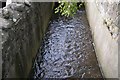
Lerburne
A partially culverted stream along the road.
Image: © Bob Harvey
Taken: 12 Oct 2019
0.03 miles
4
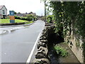
Along The Lerburne
FLowing through the heart of Wedmore are a few drainage streams. Here, at the bottom of Red Hill, the latest expansion of the housing meets the stream as it passes the ends of older gardens.
Image: © Neil Owen
Taken: 27 May 2024
0.04 miles
5
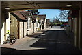
The Borough Mall, Wedmore
Viewed from beneath the entrance arch. See also http://www.geograph.org.uk/search.php?i=61991137 .
Image: © Derek Harper
Taken: 25 Mar 2016
0.04 miles
6
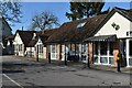
The Borough Mall, Wedmore
A range of small shopping and business units, including the village Post Office, further to the left.
Image: © David Martin
Taken: 19 Feb 2023
0.04 miles
7
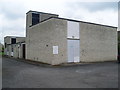
Wedmore Telephone Exchange
Situated off the B3151 Cheddar Road, this TE replaced the former TE in Grant's Lane in the early 1970s, ST4347 refers. Besides Wedmore, this TE also serves Bagley, Blackford, Chapel Allerton, Clewer, Cocklake, Crickham, Heath House, Mudgley, Sand, Stone Allerton, Theale, West Stoughton and Westham nearby. The two BT warning notices can be seen on the front of this TE. It has (01934) 71xxxx numbers and its postcode is BS28 4EQ.
Image: © David Hillas
Taken: 14 Apr 2011
0.04 miles
8
Building site
When does a village become a town?
Image: © Bob Harvey
Taken: 12 Oct 2019
0.04 miles
9
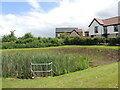
Balancing pond on Cross Farm Green
New housing on The Borough has covered over an older water feature. With modern climate dynamics in mind, the development has included a balancing pond in the case of extreme rainfall.
Image: © Neil Owen
Taken: 27 May 2024
0.04 miles
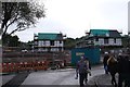
10
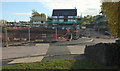
Housing development, Wedmore
New houses rising by The Lerburne. According to maps, that most prominent building is just about sitting in a pond, which I assume got drained first. Two public footpaths cross the construction site, 40UC049 AX 27/51 to the left and 40UC049 AX 27/51 to the right.
Image: © Derek Harper
Taken: 3 Nov 2019
0.04 miles