IMAGES TAKEN NEAR TO
Plud Street, WEDMORE, BS28 4BE
Introduction
This page details the photographs taken nearby to Plud Street, BS28 4BE by members of the Geograph project.
The Geograph project started in 2005 with the aim of publishing, organising and preserving representative images for every square kilometre of Great Britain, Ireland and the Isle of Man.

There are currently over 7.5m images from over14,400 individuals and you can help contribute to the project by visiting https://www.geograph.org.uk
Image Map (Loading...)


Getting Data...Please wait
Leaflet Map data © OpenStreetMap
Images are licensed for reuse under creativecommons.org/licenses/by-sa/2.0
Notes
- Clicking on the map will re-center to the selected point.
- The higher the marker number, the further away the image location is from the centre of the postcode.
Image Listing (15 Images Found)
Images are licensed for reuse under creativecommons.org/licenses/by-sa/2.0
Image
Details
Distance
1
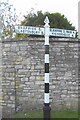
Direction Sign ? Signpost on West End, Wedmore
Located on the southwest side of the T junction of West End and Plud Street in Wedmore parish. 2 arms and pyramid spear finial.
Milestone Society National ID: SO_ST4347C
Image: © J Dowding
Taken: 11 May 2021
0.04 miles
2
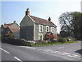
Chestnut Cottage, West End, Wedmore
Sporting posters for the Liberal Democratic Party, in the run up to the 2010 General Election.
Image: © Roger Cornfoot
Taken: 23 Apr 2010
0.12 miles
3
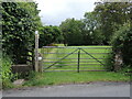
Footpath from Pilcorn Street
The path leads to the centre of the village on Guildhall Lane, although the large sign denoting 'private property' makes its presence felt.
Image: © Neil Owen
Taken: 27 May 2024
0.14 miles
4
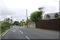
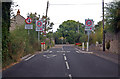
Traffic Calming at Wedmore
This chicane and a 20 mph speed limit on the B3139 Blackford Rd at the western end of the village is to slow traffic down in the vicinity of the local village school.
Image: © Nigel Mykura
Taken: 5 Aug 2015
0.15 miles
5
Entering 20 MPH limit on Pilcorn Street
The B3139 passes near to a school here.
Image: © J.Hannan-Briggs
Taken: 31 Jul 2014
0.16 miles
6
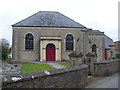
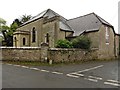
Wedmore Methodist Church
Situated in Sand Road, this church was built in 1817 of local Wedmore Stone and is a Grade 2 listed building. The Sunday School was built in 1896, and the church was refurbished in 1901 when a porch was added. It is one of 28 Methodist Churches in the Somerset Mendip Circuit and services are held at 10.30am each Sunday, with activities taking place during the week. The postcode of this church is BS28 4BZ.
Image: © David Hillas
Taken: 14 Apr 2011
0.16 miles
8
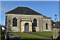
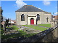
Former Wedmore Methodist Church
So far as we could tell from the signage, the church had quite recently closed and everything is looking well cared for.
Image: © David Martin
Taken: 19 Feb 2023
0.16 miles
10
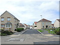
Longfield Drive
Wedmore has moved outwards in recent years and this is the latest addition to the housing on the west side, now occupying the former fields beside the school.
Image: © Neil Owen
Taken: 27 May 2024
0.18 miles