IMAGES TAKEN NEAR TO
Notting Hill Way, AXBRIDGE, BS26 2NQ
Introduction
This page details the photographs taken nearby to Notting Hill Way, BS26 2NQ by members of the Geograph project.
The Geograph project started in 2005 with the aim of publishing, organising and preserving representative images for every square kilometre of Great Britain, Ireland and the Isle of Man.

There are currently over 7.5m images from over14,400 individuals and you can help contribute to the project by visiting https://www.geograph.org.uk
Image Map (Loading...)


Getting Data...Please wait
Leaflet Map data © OpenStreetMap
Images are licensed for reuse under creativecommons.org/licenses/by-sa/2.0
Notes
- Clicking on the map will re-center to the selected point.
- The higher the marker number, the further away the image location is from the centre of the postcode.
Image Listing (17 Images Found)
Images are licensed for reuse under creativecommons.org/licenses/by-sa/2.0
Image
Details
Distance
1
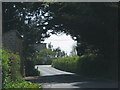
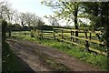
Trees meet across this minor road
Image: © Sarah Charlesworth
Taken: 26 Apr 2010
0.03 miles
2
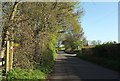
Notting Hill Way, Stone Allerton
The road to Lower Weare passes footpaths AX 26/3 on the right and AX 26/5 on the left
Image: © Derek Harper
Taken: 4 May 2016
0.04 miles
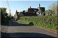
3
Dunkerry Road
Leading away from Notting Hill Way (foreground) to the centre of Stone Allerton.
Image: © Derek Harper
Taken: 4 May 2016
0.07 miles
4
Mill House, Stone Allerton
Another view of the distinctive house shown in Image, built on a former windmill which is described by Martin Watts at http://www.b-i-a-s.org.uk/BIAS_Journal6_WINDMILLS_OF_SOMERSET.pdf :"known originally as 'Weare Mill', {it} was built in 1760 and worked until the end of the 19th century ... incorporated into a new dwelling built in 1910-11".
Image: © Derek Harper
Taken: 4 May 2016
0.08 miles
5
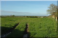
Track, Stone Allerton
A driveway from Mill Lane, passing a grass field.
Image: © Derek Harper
Taken: 4 May 2016
0.10 miles
6
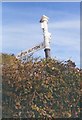
Direction Sign - Signpost on Notting Hill Way
Pyramid finial - 3 arms, 2 missing; Somerset SCC pyramid by the UC road, in parish of Weare (Sedgemoor District), in Stone Allerton on the southeast side of the junction of Notting Hill Way and Mill Lane. See https://www.flickr.com/photos/13171205@N08/8372066914/ for a 2007 photo before the two arms were lost.
Surveyed
Milestone Society National ID: SO_ST4051B
Image: © J Dowding
Taken: Unknown
0.10 miles
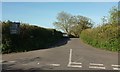
7
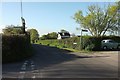
Notting Hill Way, Stone Allerton
A busy road linking the A38 at Lower Weare to Wedmore, seen at the junction with Mill Lane, and with a footpath AX 26/38.
Image: © Derek Harper
Taken: 4 May 2016
0.11 miles
8
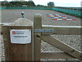
others.sprouting.unfit
A What3Words sign on a horse training paddock, deep in the heart of Somerset. It is somewhat disconcerting to have it here, perhaps horse-riding is more dangerous than it seems.
Image: © Neil Owen
Taken: 11 Oct 2020
0.12 miles
9

Notting Hill Way
Overhung by a newly-leaved tree as it approaches Badgworth Lane.
Image: © Derek Harper
Taken: 4 May 2016
0.13 miles
10
Towards Stone Allerton
From a gateway just to the left of the scene in Image], with Dunkerry Road behind the hedge of the right. The main part of the village is on the slope down to the levels of Allerton Moor.
Image: © Derek Harper
Taken: 4 May 2016
0.14 miles