IMAGES TAKEN NEAR TO
Mill Lane, AXBRIDGE, BS26 2NB
Introduction
This page details the photographs taken nearby to Mill Lane, BS26 2NB by members of the Geograph project.
The Geograph project started in 2005 with the aim of publishing, organising and preserving representative images for every square kilometre of Great Britain, Ireland and the Isle of Man.

There are currently over 7.5m images from over14,400 individuals and you can help contribute to the project by visiting https://www.geograph.org.uk
Image Map
Images are licensed for reuse under creativecommons.org/licenses/by-sa/2.0
Notes
- Clicking on the map will re-center to the selected point.
- The higher the marker number, the further away the image location is from the centre of the postcode.
Image Listing (16 Images Found)
Images are licensed for reuse under creativecommons.org/licenses/by-sa/2.0
Image
Details
Distance
1
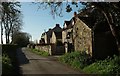
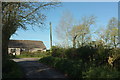
Houses on Mill Lane
Just round the bend from Image] and approaching the junction where Alston Sutton Road coninues ahead and Mill Lane turns off right to Stone Allerton.
Image: © Derek Harper
Taken: 4 May 2016
0.01 miles
2
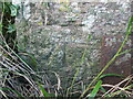
Benchmark on a gatepost on Alston Sutton Road
Right in the middle of the countryside is a stone post with a benchmark on it. See Image] for a look around and https://www.bench-marks.org.uk/bm135428 for the entry in the Benchmark Database.
Image: © Neil Owen
Taken: 11 Oct 2020
0.03 miles
3
A view of Jackets Wood
Strange name - there doesn't seem to be much in the way of trees here. What is here is a benchmark, cut on a stone post that appears to be the original gatepost before the wooden one arrived. See Image] for a closer look.
Image: © Neil Owen
Taken: 11 Oct 2020
0.03 miles
4
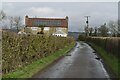
Approaching the northern end of Mill Lane
Image: © David Martin
Taken: 18 Feb 2023
0.03 miles
5
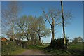
Bend on Greenhill Lane
A barn at a right-angled bend on the winding lane to Stone Allerton.
Image: © Derek Harper
Taken: 4 May 2016
0.03 miles
6
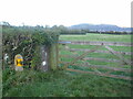
Footpath from Greenhill Lane
Footpath AX 26/4 leaves from the bend shown in Image] through the gate up the central track.
Image: © Derek Harper
Taken: 4 May 2016
0.05 miles
7
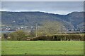
Field with view towards the Mendips
Cheddar Reservoir is visible on the left, with Cheddar Gorge cut into the hills on the right.
Image: © David Martin
Taken: 18 Feb 2023
0.08 miles
8
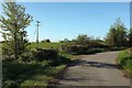
Greenhill Lane
The lane bends right at the end of the stretch shown in Image
Image: © Derek Harper
Taken: 4 May 2016
0.10 miles
9
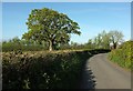
Oak by Mill Lane
Mill Lane leads from Alston Sutton to the busy road between Wedmore and Lower Weare.
Image: © Derek Harper
Taken: 4 May 2016
0.12 miles
10
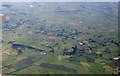
Countryside around Weare from the air
With part of the Somerset Levels southwest of Axbridge below. The white area just above the village Weare shows the premises of Premium Timber Products - see Image
Image: © Derek Harper
Taken: 8 Sep 2016
0.12 miles