IMAGES TAKEN NEAR TO
Notting Hill Way, AXBRIDGE, BS26 2JN
Introduction
This page details the photographs taken nearby to Notting Hill Way, BS26 2JN by members of the Geograph project.
The Geograph project started in 2005 with the aim of publishing, organising and preserving representative images for every square kilometre of Great Britain, Ireland and the Isle of Man.

There are currently over 7.5m images from over14,400 individuals and you can help contribute to the project by visiting https://www.geograph.org.uk
Image Map
Images are licensed for reuse under creativecommons.org/licenses/by-sa/2.0
Notes
- Clicking on the map will re-center to the selected point.
- The higher the marker number, the further away the image location is from the centre of the postcode.
Image Listing (34 Images Found)
Images are licensed for reuse under creativecommons.org/licenses/by-sa/2.0
Image
Details
Distance
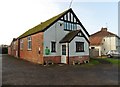
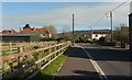
2
Semis, Lower Weare
On the last stretch of Notting Hill Way before it meets the A38.
Image: © Derek Harper
Taken: 4 May 2016
0.04 miles
3
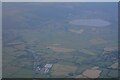
Lower Weare : Aerial View
Looking towards the reservoir from the air.
Image: © Lewis Clarke
Taken: 19 Jun 2022
0.08 miles
4
A38 at Lower Weare
Looking across the main road, here called "Turnpike Road", at the junction with Notting Hill Way. I wanted to cross here, or within a short distance to the right. Traffic patterns are variable on what is a much-used route to Bristol Airport; sometimes it seems as if there will never be a suitable gap, and there was a bit of a queue on Notting Hill Way of traffic waiting to turn right, without the benefit of traffic lights. But suddenly the road can become deserted, at least for a few seconds.
Image: © Derek Harper
Taken: 4 May 2016
0.09 miles
5
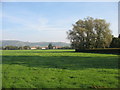
Lower Weare from the south
A public footpath running west from the primary school provided the opportunity for this shot.
Image: © David Purchase
Taken: 2 Oct 2011
0.10 miles
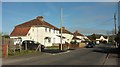
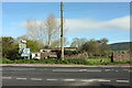
6
Notting Hill Way, Lower Weare
The road from Wedmore entering built-up area of Lower Weare, with an older cottage (with solar panels) surviving amidst more modern housing. There's also a farm immediately right of the camera.
Image: © Derek Harper
Taken: 4 May 2016
0.10 miles
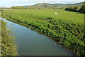
7
Lower Weare : River Axe
The River Axe heads underneath the A38 road.
Image: © Lewis Clarke
Taken: 9 Apr 2017
0.11 miles
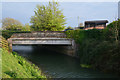
8
Axe at Lower Weare
Like Image, a view down the River Axe from Weare Bridge, but at an angle to include Crook Peak on the Mendip horizon. Downstream is a bridge carrying a farm track.
Image: © Derek Harper
Taken: 4 May 2016
0.12 miles
9
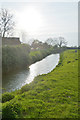
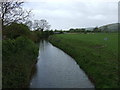
Lower Weare : River Axe
Looking along the River Axe.
Image: © Lewis Clarke
Taken: 9 Apr 2017
0.13 miles