IMAGES TAKEN NEAR TO
Polestar Way, WESTON-SUPER-MARE, BS24 7BT
Introduction
This page details the photographs taken nearby to Polestar Way, BS24 7BT by members of the Geograph project.
The Geograph project started in 2005 with the aim of publishing, organising and preserving representative images for every square kilometre of Great Britain, Ireland and the Isle of Man.

There are currently over 7.5m images from over14,400 individuals and you can help contribute to the project by visiting https://www.geograph.org.uk
Image Map (Loading...)


Getting Data...Please wait
Leaflet Map data © OpenStreetMap
Images are licensed for reuse under creativecommons.org/licenses/by-sa/2.0
Notes
- Clicking on the map will re-center to the selected point.
- The higher the marker number, the further away the image location is from the centre of the postcode.
Image Listing (69 Images Found)
Images are licensed for reuse under creativecommons.org/licenses/by-sa/2.0
Image
Details
Distance
1
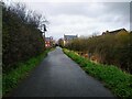
Moor Lane, Locking Castle, Weston-super-Mare
This section of Moor Lane is a traffic-free route through Locking Castle housing estate.
Image: © Jaggery
Taken: 27 Jul 2011
0.03 miles
2
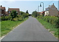
Moor Lane looking Northeast
Moor Lane looking Northeast. This road was originally a country lane until the Locking Castle development in the 1990s and 2000s resulted in the closure of most of Moor Lane to motor traffic on 20th November 2008.
Image: © s
Taken: 30 Mar 2023
0.04 miles
3
Moor Lane looking Northeast
Moor Lane looking Northeast. This road was originally a country lane until the Locking Castle development in the 1990s and 2000s resulted in the closure of most of Moor Lane to motor traffic on 20th November 2008. The houses on the left were built in 2003. The cream-coloured house and adjacent homes were built in 2004, following the demolition of Lypstone Farm.
Image: © s
Taken: 30 Mar 2023
0.06 miles
4
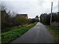
Moor Lane looking Southwest
Moor Lane looking Southwest. This road was originally a country lane until the Locking Castle development in the 1990s and 2000s resulted in the closure of most of Moor Lane to motor traffic on 20th November 2008.
Image: © s
Taken: 30 Mar 2023
0.07 miles
5
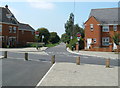
Moor Lane crosses Vale Mill Way, Locking Castle, Weston-super-Mare
The "no motor vehicles allowed" restriction on the camera side of Moor Lane is relaxed a little on the far side of Vale Mill Way. Buses are allowed ahead.
Image: © Jaggery
Taken: 27 Jul 2011
0.08 miles
6
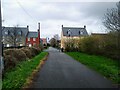
Moor Lane and Bransby Way Junction
Junction of Moor Lane and Bransby Way (road to the left). The homes on the left were built in 2003, and the homes on the right (including the cream-coloured house and the red brick houses behind the stone wall) were built in 2004 following the demolition of Lypstone Farm as part of the Locking Castle development.
Image: © s
Taken: 30 Mar 2023
0.08 miles
7
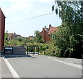
SW end of Bransby Way, Locking Castle, Weston-super-Mare
Beyond the metal barriers at the SW end of Bransby Way is Moor Lane.
Image: © Jaggery
Taken: 27 Jul 2011
0.09 miles
8
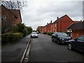
Bransby Way looking Northeast
Bransby Way looking Northeast. Bransby Way was built in 1998 as part of the Locking Castle development.
Image: © s
Taken: 30 Mar 2023
0.10 miles
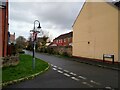
9
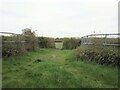
Steps up to the A370 crossing
Steps that lead to a crossing over the A370 Somerset Avenue (built in 1996) to Weston Village.
Image: © s
Taken: 16 Apr 2023
0.12 miles
10
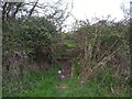
Bridge over a rhyne leading to a public footpath to Locking Head Farm
Image: © s
Taken: 16 Apr 2023
0.12 miles