IMAGES TAKEN NEAR TO
Uphill Wharf, WESTON-SUPER-MARE, BS23 4XR
Introduction
This page details the photographs taken nearby to Uphill Wharf, BS23 4XR by members of the Geograph project.
The Geograph project started in 2005 with the aim of publishing, organising and preserving representative images for every square kilometre of Great Britain, Ireland and the Isle of Man.

There are currently over 7.5m images from over14,400 individuals and you can help contribute to the project by visiting https://www.geograph.org.uk
Image Map (Loading...)


Getting Data...Please wait
Leaflet Map data © OpenStreetMap
Images are licensed for reuse under creativecommons.org/licenses/by-sa/2.0
Notes
- Clicking on the map will re-center to the selected point.
- The higher the marker number, the further away the image location is from the centre of the postcode.
Image Listing (167 Images Found)
Images are licensed for reuse under creativecommons.org/licenses/by-sa/2.0
Image
Details
Distance
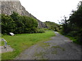
2
A well preserved limekiln at Uphill
Lime had 3 major uses, as a fertilizer, in mortar and when slaked in water as whitewash. This coastal location was convenient for coal shipped in from Wales and facile export by boat.
Image: © Dr Duncan Pepper
Taken: 27 Nov 2015
0.01 miles
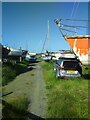
3
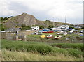
Uphill boat yard
Along with the sluice gate, and the old church of St Nicholas perched above the old quarry. See Image] for some detail of the sluice.
Image: © Neil Owen
Taken: 8 Aug 2013
0.03 miles
4
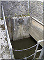
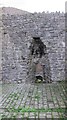
The Great Rhyne
Part of the sluice gate before the rhyne empties out into the River Axe. An information plaque reveals that the area of Uphill is actually below the level of the highest tides! Evidence has been found of a sluice dating back to the beginning of the 1600s. Subsequent modernisation and repairs have been carried out: in WWII prisoners built a new one; after the devastating flood of December 1981, more repairs were needed.
However, the old mechanisms were in need of total replacement and so these works were made in 2004.
See Image] for a wider view of the sluice.
Image: © Neil Owen
Taken: 8 Aug 2013
0.03 miles
5

Flower boat
Uphill has a nautical theme to the area, marked by a boat that is not quite seaworthy at present.
Image: © Neil Owen
Taken: 25 Apr 2023
0.03 miles
6
Uphill old Boat yard
Things seem to be at a standstill in the boatyard, no doubt later in the day work will commence to get things moving toward some repairs perhaps.
Image: © Ant Basterfield
Taken: 18 Jul 2021
0.03 miles
7

Numbered bin
An ordinary-looking bin save for a number. Where is 36? Or indeed 38?
Image: © Neil Owen
Taken: 8 Aug 2013
0.03 miles
8
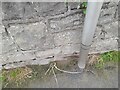
Ordnance Survey Cut Mark
This OS cut mark can be found on the wall SW side of Links Road. It marks a point 6.264m above mean sea level
Image: © Adrian Dust
Taken: 31 Jul 2023
0.04 miles
9
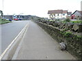
Along Uphill Way
The road carries the rhyne alongside but also features some stones set into the wall. They are recorded as 'Sea wall works boundary stone' and are post-mediaeval in date. See https://www.geograph.org.uk/photo/7521747 for a look.
Image: © Neil Owen
Taken: 25 Apr 2023
0.04 miles
10
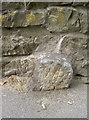
Swallowed by the pavement
Not swallowed by the water - which would have more than likely happened over the years gone by. A boundary (?) stone on the Great Rhyne Image], a partner to another: Image
Image: © Neil Owen
Taken: 8 Aug 2013
0.04 miles