IMAGES TAKEN NEAR TO
Locking Road, WESTON-SUPER-MARE, BS23 3HL
Introduction
This page details the photographs taken nearby to Locking Road, BS23 3HL by members of the Geograph project.
The Geograph project started in 2005 with the aim of publishing, organising and preserving representative images for every square kilometre of Great Britain, Ireland and the Isle of Man.

There are currently over 7.5m images from over14,400 individuals and you can help contribute to the project by visiting https://www.geograph.org.uk
Image Map
Images are licensed for reuse under creativecommons.org/licenses/by-sa/2.0
Notes
- Clicking on the map will re-center to the selected point.
- The higher the marker number, the further away the image location is from the centre of the postcode.
Image Listing (18 Images Found)
Images are licensed for reuse under creativecommons.org/licenses/by-sa/2.0
Image
Details
Distance
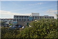
1
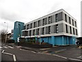
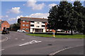
168 Medical Centre, Weston-Super-Mare
Image: © Roger Cornfoot
Taken: 31 Jan 2018
0.05 miles
4
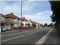
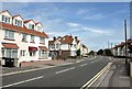
Locking Road, Weston-Super-Mare
The B3440 curves past a bus stop just east of the junction with Birchwood Avenue.
Image: © Derek Harper
Taken: 10 Aug 2011
0.06 miles
5
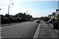
Locking Road, Weston-Super-Mare
On the left is the Abingdon guest house, at the junction with Hill View Road.
Image: © Derek Harper
Taken: 10 Aug 2011
0.13 miles
6
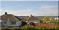
1950's Housing in Weston super Mare
These former council properties are nearly all privately owned now and very well kept. these are sited on a roundabout between the Milton and Locking roads
Image: © Ant Basterfield
Taken: 23 Jun 2009
0.14 miles
8
Earlham Grove Weston Super Mare
Some more of the 1950's former council houses, seen here at the eastern end of Earlham Grove.
Image: © Ant Basterfield
Taken: 23 Jun 2009
0.17 miles
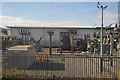
10
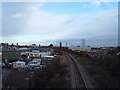
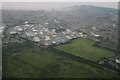
Railway Line
Here is the view from Langford road footbridge looking eastwards over the sprawling light industrial units that always seem to back on to railway lines in every town
Image: © Ant Basterfield
Taken: 16 Feb 2010
0.20 miles