IMAGES TAKEN NEAR TO
Albert Avenue, WESTON-SUPER-MARE, BS23 1YS
Introduction
This page details the photographs taken nearby to Albert Avenue, BS23 1YS by members of the Geograph project.
The Geograph project started in 2005 with the aim of publishing, organising and preserving representative images for every square kilometre of Great Britain, Ireland and the Isle of Man.

There are currently over 7.5m images from over14,400 individuals and you can help contribute to the project by visiting https://www.geograph.org.uk
Image Map
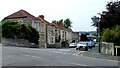
Images are licensed for reuse under creativecommons.org/licenses/by-sa/2.0
Notes
- Clicking on the map will re-center to the selected point.
- The higher the marker number, the further away the image location is from the centre of the postcode.
Image Listing (79 Images Found)
Images are licensed for reuse under creativecommons.org/licenses/by-sa/2.0
Image
Details
Distance
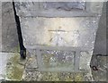
2
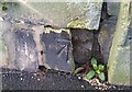
Ordnance Survey Cut Mark
This damaged OS cut mark can be found on the post of No2 Whitecross Road. It marks a point 9.723m above mean sea level.
Image: © Adrian Dust
Taken: 9 Dec 2019
0.06 miles
3
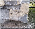
Ordnance Survey Cut Mark
This very worn OS cut mark can be found on the gatepost of No30 Ellenborough Park South. It marks a point 9.513m above mean sea level.
Image: © Adrian Dust
Taken: 9 Dec 2019
0.06 miles
4
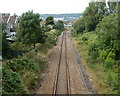
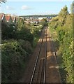
One track into two, Weston-super-Mare
Viewed from this http://www.geograph.org.uk/photo/3132592 bridge.
The railway line becomes double track ahead on the approach to Weston-super-Mare railway station.
Image: © Jaggery
Taken: 27 Jul 2011
0.07 miles
5
Railway line, Weston-Super-Mare
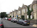
From Brighton Road looking towards the station. The nearer gable-ended houses are on Dickenson Road; the further houses are on Ridgeway Avenue. The distant white building must be the police station Image
Image: © Derek Harper
Taken: 18 Oct 2016
0.08 miles
6
Ordnance Survey Cut Mark
This OS cut mark can be found on the gatepost of No4 Langport Road. It marks a point 9.284m above mean sea level.
Image: © Adrian Dust
Taken: 9 Dec 2019
0.09 miles
7
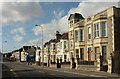
Clevedon Road, Weston-super-Mare
Continuing Brighton Road on the seaward side of the railway crossing. That's a fine tower at number 83. The blue frontage on the corner is a betting shop.
Image: © Derek Harper
Taken: 18 Oct 2016
0.09 miles
8
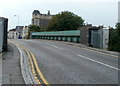
Clevedon Road railway bridge, Weston-super-Mare
The road crosses the railway about 500 metres south of Weston-super-Mare railway station.
Image: © Jaggery
Taken: 27 Jul 2011
0.10 miles
9
Sunnyside Road North, Weston-super-Mare
Viewed from the western end of Brighton Road. Sunnyside Road behind the camera becomes Sunnyside Road North ahead.
Image: © Jaggery
Taken: 27 Jul 2011
0.11 miles
10
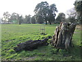
Ellenborough Park East
Like its neighbour, the park is largely devoid of much in the way of furniture or equipment. It is open grass with a ring of trees bordering the park, one of which has fallen some time ago.
Image: © Neil Owen
Taken: 13 Jan 2023
0.11 miles