IMAGES TAKEN NEAR TO
The Swallows, WESTON-SUPER-MARE, BS22 8LR
Introduction
This page details the photographs taken nearby to The Swallows, BS22 8LR by members of the Geograph project.
The Geograph project started in 2005 with the aim of publishing, organising and preserving representative images for every square kilometre of Great Britain, Ireland and the Isle of Man.

There are currently over 7.5m images from over14,400 individuals and you can help contribute to the project by visiting https://www.geograph.org.uk
Image Map
Images are licensed for reuse under creativecommons.org/licenses/by-sa/2.0
Notes
- Clicking on the map will re-center to the selected point.
- The higher the marker number, the further away the image location is from the centre of the postcode.
Image Listing (60 Images Found)
Images are licensed for reuse under creativecommons.org/licenses/by-sa/2.0
Image
Details
Distance
1
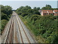
A view SW from a railway footbridge, Weston-super-Mare
Viewed from this http://www.geograph.org.uk/photo/3105464 footbridge. This is the route used by trains that bypass Weston-super-Mare railway station.
Image: © Jaggery
Taken: 27 Jul 2011
0.08 miles
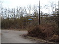
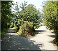
2
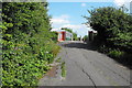
Part of the old A371
Here's a section of the old A371 where it crossed the railway line. This section of the road is now closed to all except cycle and foot traffic
Image: © Ant Basterfield
Taken: 23 Jun 2009
0.09 miles
3
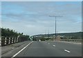
Flowerdown Bridge
The A370 crossing the railway in Weston-super-Mare.
Image: © Ruth Riddle
Taken: 17 Jul 2012
0.09 miles
4

Cycleway under the A370, Weston-super-Mare
The cycleway here follows a horseshoe-shaped route. The bend is at the western end of the horseshoe.
Image: © Jaggery
Taken: 27 Jul 2011
0.10 miles
5
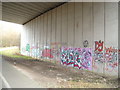
Local art? In the underpass
Here is where the cycle path goes under the A370, as you can see the local spray can artists have been at work. Once under the bridge the path turns sharp left in an E.S.E direction towards Locking and Banwell.
Image: © Ant Basterfield
Taken: 15 Feb 2010
0.13 miles
6
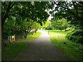
Path through Maltlands Play Area
Maltlands Play Area was built in 1996 as part of the Locking Castle development.
Image: © s
Taken: 17 May 2023
0.13 miles
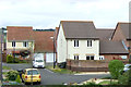
8
Maltlands looking West
The Maltlands was built in 1992. The houses on the right on Fullens Close was built in 1992.
Image: © s
Taken: 17 May 2023
0.14 miles
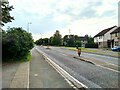
9
Cycle Paths
Here on the South eastern side of the main railway line is where two cycle paths meet. One from Worle to Banwell and one from Milton. As you can see this section runs along the side of the A370, note the crash barrier.
Image: © Ant Basterfield
Taken: 14 Feb 2010
0.14 miles
10
Triangular grass mound at a cycleway junction, Weston-super-Mare
The cycleway on the left is alongside the north side of the A370. The blue sign in the triangle shows the destinations ahead : town centre, Bournville, Uphill, Bleadon.
Image: © Jaggery
Taken: 27 Jul 2011
0.14 miles