IMAGES TAKEN NEAR TO
Sophia Gardens, WESTON-SUPER-MARE, BS22 7DS
Introduction
This page details the photographs taken nearby to Sophia Gardens, BS22 7DS by members of the Geograph project.
The Geograph project started in 2005 with the aim of publishing, organising and preserving representative images for every square kilometre of Great Britain, Ireland and the Isle of Man.

There are currently over 7.5m images from over14,400 individuals and you can help contribute to the project by visiting https://www.geograph.org.uk
Image Map
Images are licensed for reuse under creativecommons.org/licenses/by-sa/2.0
Notes
- Clicking on the map will re-center to the selected point.
- The higher the marker number, the further away the image location is from the centre of the postcode.
Image Listing (9 Images Found)
Images are licensed for reuse under creativecommons.org/licenses/by-sa/2.0
Image
Details
Distance
2
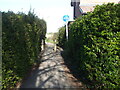
Path off Spinners End
The short path leads to the edge of the housing estate and the River Banwell.
Image: © Neil Owen
Taken: 4 Apr 2021
0.16 miles
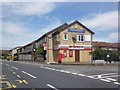
3
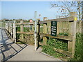
Keep the noise down
A sign on the bridge over the River Banwell implores users to make little noise so as to respect the neigbourhood - a large housing development that grew in recent years to overwhelm the former farmland. It would be helpful if the hinges and springs were not so creaky; the all-metal structure amplifies the groans badly, making quiet progress difficult.
Incidentally, the land to the north used to be the Weston, Clevedon and Portishead Railway line until WWII (it now being largely covered by the houses). A noticeboard nearby explains the history of the private line and refers to this crossing as Spinners End Bridge, after the new road opposite. However, old maps show this point as Madam Bridge, named after Madam Lane that is now also largely lost under the homes.
Image: © Neil Owen
Taken: 4 Apr 2021
0.17 miles
4
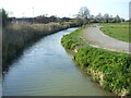
The Banwell flowing to Ebdon
As Weston-Super-Mare expands rapidly and consumes yet more flat farmland, the River Banwell forms a significant boundary. Presumably it will only be a matter of time before the new homes broach the waters and take up more flood meadows.
Image: © Neil Owen
Taken: 4 Apr 2021
0.17 miles
8
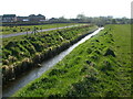
A drain near Madam Bridge
The flat landscape to the west of Weston-Super-Mare has been consumed rapidly by a massive housing development in recent years. The remaining area is officially recognised as a flood meadow that will help absorb extreme weather events and is riddled with such drainage ditches and rhynes.
Image: © Neil Owen
Taken: 4 Apr 2021
0.23 miles
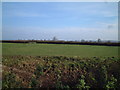
9
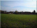
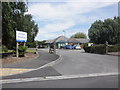
Castle Batch Recreational Area
A bit of green space totally surrounded by the ever growing 'suburbia'of Weston Super Mare
Image: © Adrian and Janet Quantock
Taken: 25 Nov 2005
0.25 miles