IMAGES TAKEN NEAR TO
Unity Street, BRISTOL, BS2 0HN
Introduction
This page details the photographs taken nearby to Unity Street, BS2 0HN by members of the Geograph project.
The Geograph project started in 2005 with the aim of publishing, organising and preserving representative images for every square kilometre of Great Britain, Ireland and the Isle of Man.

There are currently over 7.5m images from over14,400 individuals and you can help contribute to the project by visiting https://www.geograph.org.uk
Image Map
Images are licensed for reuse under creativecommons.org/licenses/by-sa/2.0
Notes
- Clicking on the map will re-center to the selected point.
- The higher the marker number, the further away the image location is from the centre of the postcode.
Image Listing (351 Images Found)
Images are licensed for reuse under creativecommons.org/licenses/by-sa/2.0
Image
Details
Distance
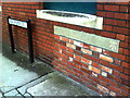
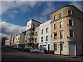
1
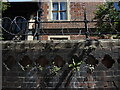
Barbed wire in Barstaple House
The old Trinity Hospital almshouses back wall has some incongruous features.
Image: © Neil Owen
Taken: 26 Apr 2022
0.03 miles
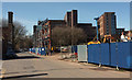
2
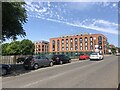
The Zinc Works
A development of modern studio apartments at the junction of Unity Street and Midland Road
Image: © Eirian Evans
Taken: 25 Jun 2023
0.04 miles
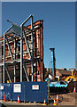
3
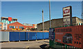
Best view of Britain, Bristol
I was scratching my head wondering why I took this until I spotted the banner on the right, and thought "Ah, yes, an attempt at irony". Beyond the junction of New Thomas Street and Unity Street is the large building site also shown in Image] and Image], with flats at Verdigris beyond on Jacob Street.
Image: © Derek Harper
Taken: 5 Apr 2018
0.04 miles
4
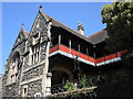
Balcony of Barstaple House
Some interesting features of the old Trinity Hospital almshouses. The original almshouses were built by a city merchant, sheriff and mayor of Bristol, John Barstaple, in about 1402. The buildings were rebuilt many times, especially between the sixteenth and nineteenth centuries, and are now private flats.
Image: © Neil Owen
Taken: 26 Apr 2022
0.05 miles
5
Benchmark on wall of former Pride of the Forest pub
Ordnance Survey cut mark benchmark described on the Bench Mark Database at http://www.bench-marks.org.uk/bm35186.
Image: © Roger Templeman
Taken: 14 Aug 2010
0.05 miles
6
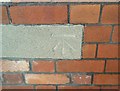
Ordnance Survey Cut Mark
This OS cut mark can be found on the Pride of the Forest PH. It marks a point 13.696m above mean sea level.
Image: © Adrian Dust
Taken: 26 Jan 2020
0.05 miles
7
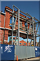
Braced facade, Unity Street, Bristol
A detail of Image
Image: © Derek Harper
Taken: 5 Apr 2018
0.05 miles
8
Braced facade, Unity Street, Bristol
Another view of the preserved facade shown in Image] and Image], with the pile driver seen in the latter.
Image: © Derek Harper
Taken: 5 Apr 2018
0.05 miles
9
Unity Street, Bristol
On the immediate left is New Thomas Street, followed by Gardiner's Warehouse - see Image Left of centre are Image], with One Temple Way beyond (architect:John Collins). Behind the pile driver is The Print Hall, recently-built student accommodation by Russ Drage Architects http://heynetillettsteel.com/projects/the-print-hall-bristol .
Image: © Derek Harper
Taken: 5 Apr 2018
0.05 miles
10
Midland Road
The building nearest the camera, on the corner of Waterloo Road, hosts the "Puzzlair 4D urban escape game" - a recent craze among young adults, which at least finds a use for otherwise disused buildings.
Image: © Stephen Craven
Taken: 24 Jun 2017
0.06 miles