IMAGES TAKEN NEAR TO
Anvil Street, BRISTOL, BS2 0FT
Introduction
This page details the photographs taken nearby to Anvil Street, BS2 0FT by members of the Geograph project.
The Geograph project started in 2005 with the aim of publishing, organising and preserving representative images for every square kilometre of Great Britain, Ireland and the Isle of Man.

There are currently over 7.5m images from over14,400 individuals and you can help contribute to the project by visiting https://www.geograph.org.uk
Image Map
Images are licensed for reuse under creativecommons.org/licenses/by-sa/2.0
Notes
- Clicking on the map will re-center to the selected point.
- The higher the marker number, the further away the image location is from the centre of the postcode.
Image Listing (641 Images Found)
Images are licensed for reuse under creativecommons.org/licenses/by-sa/2.0
Image
Details
Distance
1
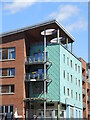
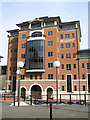
Crown and Anchor House
A modern block of apartments now stand where there was once some of Bristol's industrial heartland. As with much of the area, the style and appearance are varied. At least the light will get in.
The block occupies a couple of streets where a school and Congregational chapel once were. Perhaps the name refers to a malthouse opposite them, now lost.
Image: © Neil Owen
Taken: 7 Jul 2022
0.01 miles
2
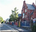
New Kingsley Road, The Dings, Bristol 2
Hannah More Primary School is named after Hannah More who was born Fishponds, Bristol in 1745 and who died in Clifton, Bristol in 1833. The school was previously known as Barley Fields Junior School. In the C19th there were hemp and flax mills and iron works opposite the school here in Upper Cheese Lane, this road’s previous name. Hannah More was an evangelical Christian writer, a poet, a playwright and a philanthropist who joined other influential individuals of her day in campaigning against the slave trade, in which Bristol was heavily involved. A previous Hannah More School, built in the 1840s, existed in Old Market, Bristol. Temple Meads Railway Station is a 10 minute walk away, behind the photographer.
Image: © David Hallam-Jones
Taken: 13 Aug 2017
0.02 miles
3
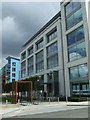
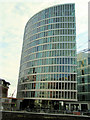
Office building
Between Avon Street and Anvil Street.
Image: © Thomas Nugent
Taken: 7 Sep 2010
0.03 miles
4
Royal Bank of Scotland Offices
On the waterfront at Avon Street, Bristol
Image: © Rick Crowley
Taken: 16 Mar 2009
0.03 miles
5
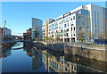
River Avon near Temple Quay with new office development
Ferry services run to here from Bristol Harbour and St Augustine's Reach - a useful, if leisurely, route for commuters to and from Temple Meads railway station.
Image: © Anthony O'Neil
Taken: 9 Dec 2010
0.03 miles
6
Waterfront Flats Completed
As of August 09 see Image Nice position walking distance of Centre and Temple Meads Station.
Image: © Rick Crowley
Taken: 21 Aug 2008
0.03 miles
7
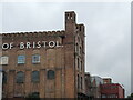
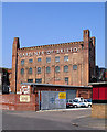
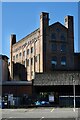
Soap and specialists
The old soap factory in Broad Plain dates back to the mid 1700s, which changed names and owners on a frequent basis. In 1865 the buildings were demolished and the present structures constructed to designs by William Bruce Gingell, who based it on Italian styles.
Gardiner Haskins moved into the old site after WWII but are now undergoing a significant company restructuring, which will probably mean them moving out.
With the impending departure, the weeds are starting to gain a foothold.
Image: © Neil Owen
Taken: 10 Sep 2021
0.05 miles
8
Historic Warehouse
Straight Street: 1865 example of Byzantine style in Bristol
Image: © Anthony O'Neil
Taken: 28 Feb 2021
0.05 miles
9

Hotel Ibis
Viewed from the new footbridge over the Floating Harbour.
Image: © Thomas Nugent
Taken: 7 Sep 2010
0.05 miles