IMAGES TAKEN NEAR TO
Hassell Drive, BRISTOL, BS2 0AH
Introduction
This page details the photographs taken nearby to Hassell Drive, BS2 0AH by members of the Geograph project.
The Geograph project started in 2005 with the aim of publishing, organising and preserving representative images for every square kilometre of Great Britain, Ireland and the Isle of Man.

There are currently over 7.5m images from over14,400 individuals and you can help contribute to the project by visiting https://www.geograph.org.uk
Image Map
Images are licensed for reuse under creativecommons.org/licenses/by-sa/2.0
Notes
- Clicking on the map will re-center to the selected point.
- The higher the marker number, the further away the image location is from the centre of the postcode.
Image Listing (123 Images Found)
Images are licensed for reuse under creativecommons.org/licenses/by-sa/2.0
Image
Details
Distance
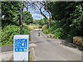
1
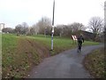
Start of railway path
This path leads from Bristol through to Bath.
Image: © DS Pugh
Taken: 27 Jun 2017
0.03 miles
2
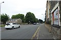
Trinity Street
Looking along Trinity Street from the junction with Clarence Road.
Image: © DS Pugh
Taken: 27 Jun 2017
0.04 miles
3
Bristol : Clarence Road
Clarence Road which is about to split into two at the building used for YMCA training.
Image: © Lewis Clarke
Taken: 1 Feb 2013
0.05 miles
4
Clarence Road
With a speeding police car.
Image: © Stephen Craven
Taken: 24 Jun 2017
0.06 miles
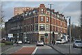
5
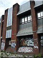
Clarence Road telephone exchange
The exchange used to occupy a smaller site just a very short distance away before moving here. The uncommon architecture is no defence against the tide of paint, though.
Image: © Neil Owen
Taken: 5 May 2022
0.06 miles
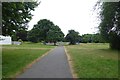
6
Mountain bike damage on the cycle path
The Bristol & Bath Railway Path was the inaugural section of the National Cycle Network when it opened in 1977. This was another age well before the advent of the mountain or all terrain bike in the UK. Riders obviously cut this corner on their way into the city centre to save a few seconds. I suppose the only answer is to put up some pedestrian guardrail as a deterrent.
Image: © John M
Taken: 1 Feb 2011
0.06 miles
7

'Twisted Arch' by Cod Steaks
The arch opened in 2007 celebrated the 30th anniversary of Sustrans. The first section of the National Cycle Network started here in Bristol as the Bristol & Bath Railway Path.
Image: © John M
Taken: 1 Feb 2011
0.07 miles
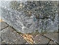
8
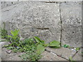
Bolt benchmark on the old Holy Trinity
The church dates from 1832 and the west end has a bolt benchmark that is just about visible today. Not only has the modern ground level risen thanks to the paviers, the stonework is crumbling so badly that the chisel marks are weathered. See https://www.bench-marks.org.uk/bm28912 for the entry in the Benchmark Database and Image] for a wider view.
Image: © Neil Owen
Taken: 5 May 2022
0.07 miles
9
Ordnance Survey 1GL Bolt
This OS bolt can be found on the SW angle of Holy Trinity Church. It marks a point 15.807m above mean sea level.
Image: © Adrian Dust
Taken: 3 Jul 2024
0.07 miles